NAVIGATION SYSTEM / MULTI INFORMATION SYSTEM
-
FUNCTION OF MAIN COMPONENTS
Component Function Navigation Receiver Assembly Receives and processes the data that is input from various components, displays various pieces of information and operating conditions on the screen, and provides voice guidance. Navigation Antenna Assembly Receives signals from GPS satellites and transmits them to the navigation receiver assembly. Steering Pad Switch Assembly Enables the driver to operate the navigation system using the steering pad switches. Telephone Microphone Assembly Transmits voice signals to the navigation receiver assembly. No. 1 Stereo Jack Adapter Assembly Transmits information about the portable audio player connected to the USB port or AUX port to the navigation receiver assembly. No. 1 Amplifier Antenna Assembly
-
AM
-
FM
-
Receives radio broadcasting signals (AM/FM).
-
Amplifies the received radio broadcasting signals using the built-in amplifier antenna assembly, and sends them to the audio head unit.
Window Glass Antenna Wire (Front)
-
DAB*1
Receives radio broadcasting signals (DAB). Digital Audio Broadcasting Antenna Assembly Amplifies DAB signals from the DAB antenna and sends them to the audio head unit. Combination Meter Assembly
-
Displays information such as audio status information received from the audio head unit on the multi-information display.*2
-
Sends operation signals to the audio head unit when the audio system is operated via the multi-information display.*2
-
Sends a vehicle speed signal to the audio head unit.
*1: Models with Digital Audio Broadcast (DAB) tuner
*2: Models with multi-information display linked function
-
-
FUNCTION
-
Navigation Screen
-
The navigation computer calculates the present position and direction of travel, determines a route and calculates the driving distance based on the following information sources:
-
Map data in the microSD card
-
Global Positioning System (GPS) satellites
-
Built-in gyro sensor
-
Vehicle speed signal
-
Reverse signal
-
Parking brake signal
-
Radio Data System Traffic Message Channel (RDS-TMC) signal (Models for Australis or South Africa)
-
Real Time Information in the Cockpit (RTIC) (Models for Philippines)
Models for Australia Item Function Map Display Taillight-interlocked Map Color Change Changes the color of the map screen when the taillights are turned on. North Up/Heading Up
-
If North Up is selected, regardless of the direction of vehicle travel, north is always up.
-
If Heading Up is selected, the direction of vehicle travel is always up.
3D Display Displays a 3-dimensional (3D) view of the map. Zoom In/Zoom Out Change the area of the map displayed on the screen. Tilt Up/Tilt Down In 3D mode, the user can change the vertical display angle of the map. Rotate Left/Rotate Right Changes the horizontal display angle of the map. Street Name Indication on Scrolled Map Displays the street name and city name even when the map screen is being scrolled. Road Number Sign Board Displays the road number on the map. Point of Interest Display Displays selected types of points of interest as marks on the map. Multiple Display Function Displays different modes on a screen that is split into 2 or 3 views. Route Guidance Demonstration Demonstrates the route guidance to the destination. Route Trace Displays a list of all trip logs, whether they were saved by the user upon reaching the destination or whether they were saved automatically. RDS-TMC Display Displays RDS-TMC icons, arrows, pop-up messages and indicators when the RDS-TMC service is being received. Help Nearby Screen The user can search for the following services around the current position of the vehicle or the latest confirmed position:
-
Car Repair Around Here: Vehicle repairs/road-side assistance services
-
Health Around Here: Hospitals/emergency services
-
Police Around Here: Police stations
-
Petrol Station Around Here: Gas stations
Destination Search Preset Destination Memory Search A destination can be set from a pre-registered point while driving. Address Search Destination information can be entered in the following order: area, town name, street name and house number. Hybrid Point of Interest Narrows the search by names of the point of interest, category and areas. Previous Destination Search Stores the coordinates, names, and date of up to 100 locations that have been set as destinations. Online Database Destination Search A point searched for using the Toyota Link apps content can be set as a destination. Point of Interest Search A destination can be set in 3 ways:
-
The name of a POI can be entered and then searched for from city or category.
-
A POI category can be selected to search for a POI near the present location, along the current route, near the city center or near the destination.
-
A POI can be searched for by its phone number.
Map Search A destination can be set by scrolling the cursor on the map. Memory Point Search A destination can be set from the registered memory point. Intersection or Motorway Entrance/Exit Search A destination can be set in 2 ways:
-
By specifying 2 streets, the point at which they intersect is set as the destination point.
-
Searches for the destination by the name of the street that connects to a motorway entrance or exit.
Address Book (Memory Point) Search A destination can be set from the registered address book (memory point). Coordinate Search A destination can be input by entering its coordinates. Route Search Multiple Destination Setting Multiple destinations can be set. The sequence of the destinations can be rearranged as well. Multiple Route Search Searches for multiple routes. Search Condition Designation Searches for quick, alternate and short routes. Destination Reordering Changes the order of destinations when more than one destination is selected. Detour Search Changes the route to detour around a section of the route. Avoidance Area Searches for a route that avoids a designated area. Auto Avoid Traffic Search Automatically changes to another route to avoid heavy congestion. Guidance Voice Guidance Provides voice guidance about the distance and the direction of travel to a destination point based on road conditions and vehicle speed. Next Turn Guidance Provides guidance about the distance to the next turn and indicates the direction of the turn using an arrow. Motorway Mode Display Displays the distance to the next junction and exit, or POIs in the area around a motorway exit. Motorway Exit or Junction Display When the vehicle approaches an exit or junction, the motorway guidance screen will be displayed. Motorway Direction of Travel Display Displays the direction of travel to take on the motorway. Real Motorway Junction Display Displays the junction and signage in 3D in the area around a major junction while driving. Intersection Zoom-in Display Zooms in the image when approaching an intersection. Turn List Display Displays a turn list on the right side of the 2-screen display. Arrow (Turn-by-Turn) Display Displays the direction of the next turn and the distance to the turn on the right side of the 2- screen display. Lane List Display Displays a lane list on the right side of the 2-screen display. Distance-to-destination Display Displays the distance from the present location to the destination. Driver Support Information Icon Display Displays warning icons when the vehicle approaches areas such as school zones, railway crossings or high accident zones. Route Information Bar Display Displays the following information:
-
Street name of the current location
-
Distance and travel time to the destination
-
Distance to the destination and estimated time of arrival
-
Distance to the destination and an arrow facing the destination (when off the route during the guidance)
Traffic Bar Display Displays traffic information of congestions or accidents on the route using the traffic bar. Others Voice Recognition Recognizes pre-programmed system commands spoken to operate the navigation system. Models for G.C.C. Countries Item Function Map Display Current Position Display Displays the current position when the navigation system starts. Map Scale Changes the area of the map displayed on the screen. City Map The city map is available for some major cities. When a map scale of 50 m is selected, the map display will change to the city map in either 2D or 3D. Map Operation The orientation of the map can be changed between 2D north up 2D heading-up and 3D heading-up by selecting the orientation symbol displayed at the top left of the screen. Compass Mode Screen Displays the direction of travel and detailed data of the present location. Point of Interest Display Displays selected types of points of interest as marks on the map. Route Trace
-
Stores up to the last 200 km (124 miles) of a traveled route and retraces the route on the display.
-
Available when the map scale is set to 50 km (30 miles) or less.
Icon Information Display When the cursor is placed above an icon on the map screen, the name of the facility associated with that icon is displayed at the top of the screen. Also, when "info" is displayed at the top of the screen, detailed information can be displayed. Destination Search Address Search Destination information can be entered in the following order: area, town name, street name and house number. Point Of Interest (POI) Search The name of a POI can be entered and searched for from town or category. Point Of Interest (POI) Near Cursor Search A destination can be set by selecting a search point and POI category. The names of POIs located within approximately 30 km from the selected search point can be displayed. Search Area Selection The search area can be changed. Map Search A destination can be set by using the cursor on the map screen. Memory Point Search A destination can be set from an item in the registered memory point. Previous Destination Search Stores the coordinates, names, and dates of up to 100 locations that have been set as destinations. Intersection Search By specifying 2 streets, the point at which they intersect is set as the destination point. Motorway Entrance/Exit Search A destination can be set by inputting the name of an entrance or exit on a motorway. Coordinate Search A destination can be input by entering its coordinates. Telephone Number Search The user can find the destination by telephone number. Home Search Searches for the route to the user's home. Favorites Search If the user has favorites already registered, the destination can be found by specifying one of the favorites. Route Search Multiple Destination Setting Multiple destinations can be set. The sequence of the destinations can be rearranged as well. Multiple Route Search Searches for multiple routes. Search Condition Designation Road conditions of the route to the destination can be set. Destination Reordering Changes the order of destinations when more than one destination is selected. Detour Search Changes the route to detour around a section of the route. Avoidance Area Searches for a route that avoids a designated area. Auto Avoid Traffic Search Automatically changes to another route to avoid heavy congestion. Guidance Voice Guidance Provides voice guidance about the distance and the direction of travel to a destination point based on road conditions and vehicle speed. Next Turn Guidance Provides guidance about the distance to the next turn and indicates the direction of the turn using an arrow. Motorway (Freeway, Highway) Mode Display Displays the distance to the next junction and exit, or POIs in the vicinity of the motorway exit. Motorway (Freeway, Highway) Exit or Junction Display When the vehicle approaches an exit or junction, the motorway guidance screen will be displayed. Motorway (Freeway, Highway) Direction of Travel Display Displays the direction of travel to take on the motorway. Intersection Zoom-in Display Zooms in the map display when approaching an intersection. Turn List Display Displays a turn list on the right side of the 2-screen display. Arrow (Turn-by-Turn) Display Displays the direction of the next turn and the distance to the turn on the right side of the 2-screen display. Distance-to-destination Display Displays the distance from the present location to the destination. Route Information Bar Display Displays the following information:
-
Street name of the current location.
-
Distance and travel time to the destination.
-
Distance to the destination and estimated time of arrival.
Others Map Coverage Information Display Displays the map area that is stored on the microSD card. Models for South Africa Item Function Map Display Current Position Display Displays the current position when the navigation system starts. Map Scale Changes the area of the map displayed on the screen. City Map The city map is available for some major cities. When a map scale of 50 m is selected, the map display will change to the city map in either 2D or 3D. Map Operation The orientation of the map can be changed between 2D north up 2D heading-up and 3D heading-up by selecting the orientation symbol displayed at the top left of the screen. Compass Mode Screen Displays the direction of travel and detailed data of the present location. Point of Interest Display Displays selected types of points of interest as marks on the map. Route Trace
-
Stores up to the last 200 km (124 miles) of a traveled route and retraces the route on the display.
-
Available when the map scale is set to 50 km (30 miles) or less.
RDS-TMC Display Displays RDS-TMC icons, arrows, pop-up messages and indicators when the RDS-TMC service is being received. Icon Information Display When the cursor is placed above an icon on the map screen, the name of the facility associated with that icon is displayed at the top of the screen. Also, when "info" is displayed at the top of the screen, detailed information can be displayed. Destination Search Address Search Destination information can be entered in the following order: area, town name, street name and house number. Point Of Interest (POI) Search The name of a POI can be entered and searched for from town or category. Point Of Interest (POI) Near Cursor Search A destination can be set by selecting a search point and POI category. The names of POIs located within approximately 30 km from the selected search point can be displayed. Search Area Selection The search area can be changed. Map Search A destination can be set by using the cursor on the map screen. Memory Point Search A destination can be set from an item in the registered memory point. Previous Destination Search Stores the coordinates, names, and dates of up to 100 locations that have been set as destinations. Intersection Search By specifying 2 streets, the point at which they intersect is set as the destination point. Motorway Entrance/Exit Search A destination can be set by inputting the name of an entrance or exit on a motorway. Coordinate Search A destination can be input by entering its coordinates. Telephone Number Search The user can find the destination by telephone number. Home Search Searches for the route to the user's home. Favorites Search If the user has favorites already registered, the destination can be found by specifying one of the favorites. Route Search Multiple Destination Setting Multiple destinations can be set. The sequence of the destinations can be rearranged as well. Multiple Route Search Searches for multiple routes. Search Condition Designation Road conditions of the route to the destination can be set. Destination Reordering Changes the order of destinations when more than one destination is selected. Detour Search Changes the route to detour around a section of the route. Avoidance Area Searches for a route that avoids a designated area. Auto Avoid Traffic Search Automatically changes to another route to avoid heavy congestion. Guidance Voice Guidance Provides voice guidance about the distance and the direction of travel to a destination point based on road conditions and vehicle speed. Next Turn Guidance Provides guidance about the distance to the next turn and indicates the direction of the turn using an arrow. Motorway (Freeway, Highway) Mode Display Displays the distance to the next junction and exit, or POIs in the vicinity of the motorway exit. Motorway (Freeway, Highway) Exit or Junction Display When the vehicle approaches an exit or junction, the motorway guidance screen will be displayed. Motorway (Freeway, Highway) Direction of Travel Display Displays the direction of travel to take on the motorway. Intersection Zoom-in Display Zooms in the map display when approaching an intersection. Turn List Display Displays a turn list on the right side of the 2-screen display. Arrow (Turn-by-Turn) Display Displays the direction of the next turn and the distance to the turn on the right side of the 2-screen display. Distance-to-destination Display Displays the distance from the present location to the destination. Route Information Bar Display Displays the following information:
-
Street name of the current location.
-
Distance and travel time to the destination.
-
Distance to the destination and estimated time of arrival.
Others Map Coverage Information Display Displays the map area that is stored on the microSD card. Voice Recognition Recognizes pre-programmed system commands spoken to operate the navigation system. Models for Philippines Item Function Map Display Current Position Displays the current position when the navigation system starts. Moving (Scrolling) Map Moves the map to the user's desired location. Switching Map Orientation Switches the screen between 2D and 3D views. Street View Displays different modes on a screen that is split into 2 views. One-way Street Display Displays the one-way street mark. Changing Map Scale Changes the map scale between 10 m and 2000 km. Text Zoom Zooms in on the text of location names and Point Of Interest (POIs) displayed on the map screen. Registering Scale Scales for each map in accordance with the display method. The registered scale is displayed on the map screen when the HOME button is pressed. Setting Logo Display Displays logos of various POIs on the map. Traffic Information (RTIC) Displays traffic information such as traffic congestion, accidents and road closures on the map. Destination Search By Map Destinations can be found on the map. By Address Searches for a destination by using the destination address entered. By Home Searches for the route to the user's home. By Favorites Selects the destination from the locations to search for the destination. By History Selects the destination from the locations searched in the past to search for the destination. By Name Searches for the destination by using the destination name entered. By Near Here Specifies the category of POIs around the current location to search for the destination. By Near Destination Specifies the category of POIs around the destination to search for the destination. By Near City Specifies the city, and then the category of POIs around the city to search for the destination. By Coordinates Specifies the longitude and latitude to search for the destination. By Special Favorites If the user has special favorites already registered, the destination can be found by specifying one of the favorites. By Telephone Number The user can find the destination by telephone number. Route Search Multiple Destination Setting Sets multiple destinations:
-
Adding waypoint: A waypoint can be added to the route and used during route guidance.
-
Adding destination: A new destination can be added before or after the currently set destination(s).
-
Reordering destination: The arrival order of the multiple destinations that are set can be changed.
-
Deleting destination: A destination can be deleted.
Road Preference The user can choose whether the system uses the following items on the way to the destination:
-
Route display
-
Route search condition/criteria display
-
Distance
-
Travel time
Approaching Intersection Displays the guidance screen of the intersection. Approaching Motorway Exit or Junction Displays the guidance screen of the motorway exit or junction. Approaching a Roundabout When the user approaches a roundabout on the route, the roundabout guidance appears on the right pane. Voice Guidance During route guidance, the following types of voice guidance are provided:
-
Continue driving straight guidance
-
Right/left turn guidance
-
U-turn guidance
-
Road branching guidance
-
Destination approach/arrival guidance and so on
Editing Route The user can edit a route by confirming the set route, specifying waypoints, etc. -
-
-
Information Screen
-
The fuel consumption screen is displayed as illustrated below. This screen has the display functions listed below.
Figure 1. Models for Australia
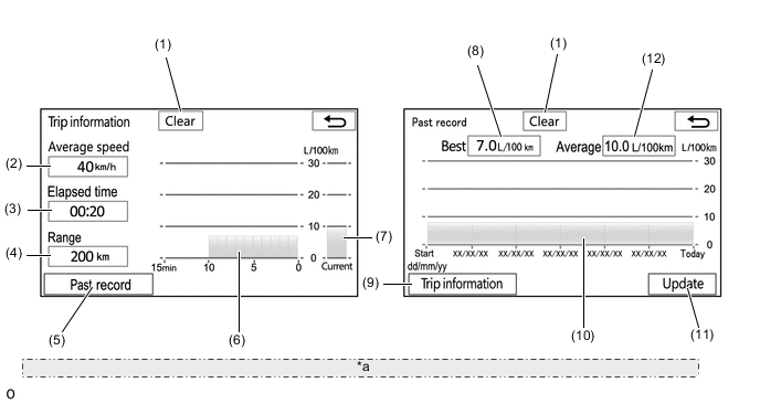
*a The illustrations shown are examples only. The illustrations may differ from the actual vehicle screens. Item Outline (1) Clear Switch Clears all past information. (2) Average Speed Displays an average speed value that has been calculated by the combination meter assembly, which is based on the distance driven and time elapsed since the ignition switch was turned to ON. (3) Elapsed Time Displays an elapsed time value that has been calculated by the combination meter assembly, which is based on the time elapsed since the ignition switch was turned to ON. (4) Range Displays the approximate drivable distance. (5) Past Record Switch Changes the screen to the past record fuel consumption screen (per trip). (6) Average Fuel Consumption per Minute
-
Displays the value that has been calculated by the combination meter assembly, which is based on the driven distance and the volume of fuel consumed (fuel injection signal), since the ignition switch was turned to ON.
-
Displays the average fuel consumption for the last minute, or since clear was last selected.
(7) Current Fuel Consumption per Minute Displays the instantaneous (current) fuel consumption value that has been calculated by the combination meter assembly, which is based on the driven distance and the volume of fuel consumed (fuel injection signal), since the ignition switch was turned to ON. (8) Best Fuel Consumption Displays the best (most economical) fuel consumption per trip. (9) Trip Information Switch Changes the screen to the average fuel consumption per minute screen. (10) Average Fuel Consumption per Trip Displays the average fuel consumption for this trip and the previous 5 trips (11) Update Switch
-
Restarts calculation of the average fuel consumption value.
-
Sends the average fuel consumption reset signal to the combination meter assembly to update the graph.
(12) Average Fuel Consumption Displays the average fuel consumption for this trip and the previous 5 trips. Figure 2. Models for G.C.C. Countries, South Africa or Philippines
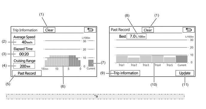
*a The illustrations shown are examples only. The illustrations may differ from the actual vehicle screens. Item Outline (1) Clear Switch Clears all past information. (2) Average Speed Displays an average speed value that has been calculated by the combination meter assembly, which is based on the distance driven and time elapsed since the ignition switch was turned to ON. (3) Elapsed Time Displays an elapsed time value that has been calculated by the combination meter assembly, which is based on the time elapsed since the ignition switch was turned to ON. (4) Cruising Range Displays the approximate drivable distance. (5) Past Record Switch Changes the screen to the past record fuel consumption screen (per trip). (6) Average Fuel Consumption per Minute
-
Displays the value that has been calculated by the combination meter assembly, which is based on the driven distance and the volume of fuel consumed (fuel injection signal), since the ignition switch was turned to ON.
-
Displays the average fuel consumption for the last minute, or since clear was last selected.
(7) Current Fuel Consumption per Minute Displays the instantaneous (current) fuel consumption value that has been calculated by the combination meter assembly, which is based on the driven distance and the volume of fuel consumed (fuel injection signal), since the ignition switch was turned to ON. (8) Best Fuel Consumption Displays the best (most economical) fuel consumption per trip. (9) Trip Information Switch Changes the screen to the average fuel consumption per minute screen. (10) Average Fuel Consumption Displays the average fuel consumption for this trip and the previous 5 trips (11) Update Switch
-
Restarts calculation of the average fuel consumption value.
-
Sends the average fuel consumption reset signal to the combination meter assembly to update the graph.
-
-
-
Setup Screen
-
The settings for the functions of the navigation receiver assembly are available from the "Setup" screen.
Models for Australia Item Function General Settings
-
System Time: The time zone and the on/off setting of daylight saving time can be changed.
-
Unit of Measurement: The unit of measurement for fuel consumption can be changed.
-
Beep: The selection sound can be set.
-
Color Theme: The color of the screen buttons can be changed.
-
Keyboard Layout: The keyboard layout can be changed.
-
Auto Change to Home Screen: Automatic screen changes can be turned on or off. When turned on, the screen automatically returns to the home screen from the audio/visual control screen after 20 seconds of inactivity.
-
Touch Switch Sensitivity: The user can adjust the sensitivity level of the electrostatic type switches.
-
Animation: The user can turn on or off some animations displayed on the screens, such as ones for list scrolling.
-
Customize Startup Image: The startup images can be set.
-
Customize Screen Off Image: The screen off images can be set.
-
Delete Personal Data: Registered information (personal data) can be cleared.
-
Software Update: The software versions can be updated.
-
Software Information: Third party software information used in the navigation system, such as notices, can be displayed.
Home Screen Setting The layout and display items on the home screen can be changed. Voice Settings
-
The voice guidance volume can be adjusted.
-
Voice guidance during route guidance can be set.
-
Automatic volume settings for voice guidance while driving at high speeds can be set.
-
Voice recognition prompts can be set.
Display Settings The brightness, contrast, tone and color of the screen can be adjusted and the display can be changed to day or night mode. Bluetooth Settings
-
Bluetooth device registration settings can be changed:
-
Register a Bluetooth device
-
Delete a Bluetooth device
-
Connect a Bluetooth device
-
Edit a Bluetooth device
-
Bluetooth system settings can be changed:
-
Automatic connection to a Bluetooth device
-
Bluetooth device name
-
Bluetooth device PIN-code
-
Bluetooth device address
-
Display of Bluetooth device connection status
-
Bluetooth device profile
Telephone Settings
-
A Bluetooth phone can be registered or connected.
-
Phone sound settings can be changed:
-
Ring tone
-
Ring tone volume
-
Message reading volume
-
Incoming SMS/MMS tone
-
Incoming SMS/MMS volume
-
Incoming E-mail tone
-
Incoming E-mail volume
-
In-call volume
-
Contact/Call history settings can be changed:
-
Automatic contact/history transfer function settings when a PBAP-compatible Bluetooth phone is connected
-
Contacts update
-
Contacts sorting
-
Favorites list registration
-
Contacts deletion from the favorites list
-
Contact image display
-
Call history deletion
-
New contact addition to the contact list
-
Contact list editing
-
Contact deletion from the contact list
-
Message function settings can be changed:
-
Message forwarding from cellular phones
-
Automatic message readout
-
SMS/MMS notification pop-up
-
E-mail notification pop-up
-
Vehicle signature on outgoing messages
-
Message readout status on phone update
-
Incoming SMS/MMS display when an SMS/MMS message is received
-
"Full Screen": The incoming SMS/MMS display screen is displayed and can be operated on the screen.
-
"Drop-Down": A message is displayed on the upper side of the screen.
-
Incoming e-mail display when an e-mail is received
-
"Full Screen": The incoming e-mail display screen is displayed and can be operated on the screen.
-
"Drop-Down": A message is displayed on the upper side of the screen.
-
Display of messaging account names on the inbox tab
-
Telephone display settings can be changed:
-
Incoming call display
-
Display of the automatic contact/history transfer completion message
Audio Settings
-
FM radio settings can be changed:
-
The station list can be updated.
-
The FM radio text feature can be set.
-
DAB settings can be changed:
-
The station list can be updated.
-
L-band in the tune range can be set.
-
Setting to automatically seek a DAB station that regularly broadcasts traffic information and station broadcasts can be set.
-
Setting to automatically select a DAB station providing good reception if current reception worsens can be set.
-
The DAB text feature can be set.
-
An input terminal for iPod audio sound signals can be selected.
-
An input video signal format can be selected.
-
The display of cover art can be set to on or off.
Toyota Link Settings
-
The voice guidance volume can be adjusted.
-
Settings for telephone data plan pop-ups can be changed to:
-
Once per drive
-
Every time
-
Never display
Navigation Settings* The navigation settings can be used to:
-
Set and edit the home.
-
Set preset destinations.
-
Set and edit the address book.
-
Set and edit the areas to avoid.
-
Delete previous destinations.
-
Set detailed navigation settings such as:
-
The average cruising speed
-
The pop-up information display
-
The displayed POI icon categories
-
The voice guidance for the next street name
-
The viewing angle of the 3D map
-
Driver support information
-
The current vehicle position mark which can be manually adjusted
Tech Tips
*: Navigation settings are changed by pressing the corresponding switch displayed on the screen.
Models for G.C.C. Countries Item Function General Settings
-
System Time: The time zone and the on/off setting of daylight saving time can be changed.
-
Language: The language can be selected.
-
Beep: The selection sound can be set.
-
Color Theme: The color of the screen buttons can be changed.
-
Auto Change to Home Screen: Automatic screen changes can be turned on or off. When turned on, the screen automatically returns to the home screen from the audio/visual control screen after 20 seconds of inactivity.
-
Touch Switch Sensitivity: The user can adjust the sensitivity level of the electrostatic type switches.
-
Animation: The user can turn on or off some animations displayed on the screens, such as ones for list scrolling.
-
Customize Startup Image: The startup images can be set.
-
Customize Screen Off Image: The screen off images can be set.
-
Delete Personal Data: Registered information (personal data) can be cleared.
-
Software Update: The software versions can be updated.
-
Software Information: Third party software information used in the navigation system, such as notices, can be displayed.
Home Screen Setting The layout and display items on the home screen can be changed. Voice Settings
-
The voice guidance volume can be adjusted.
-
Voice guidance during route guidance can be set.
Display Settings The brightness, contrast, tone and color of the screen can be adjusted and the display can be changed to day or night mode. Bluetooth Settings
-
Bluetooth device registration settings can be changed:
-
Register a Bluetooth device
-
Delete a Bluetooth device
-
Connect a Bluetooth device
-
Edit a Bluetooth device
-
Bluetooth system settings can be changed:
-
Automatic connection to a Bluetooth device
-
Bluetooth device name
-
Bluetooth device PIN-code
-
Bluetooth device address
-
Display of Bluetooth device connection status
-
Bluetooth device profile
Telephone Settings
-
A Bluetooth phone can be registered or connected.
-
Phone sound settings can be changed:
-
Ring tone
-
Ring tone volume
-
In-call volume
-
Contact/Call history settings can be changed:
-
Automatic contact/history transfer function settings when a PBAP-compatible Bluetooth phone is connected
-
Contacts update
-
Contacts sorting
-
Favorites list registration
-
Contacts deletion from the favorites list
-
Contact image display
-
Call history deletion
-
New contact addition to the contact list
-
Contact list editing
-
Contact deletion from the contact list
-
Voice tag management
-
Telephone display settings can be changed:
-
Incoming call display
-
Display of the automatic contact/history transfer completion message
Audio Settings
-
FM radio settings can be changed:
-
The FM radio text feature can be set
-
An input terminal for iPod audio sound signals can be selected.
-
An input video signal format can be selected.
-
The display of cover art can be set to on or off.
Navigation Settings The navigation settings can be used to:
-
Set detailed navigation settings such as average cruising speed.
-
Set detailed navigation settings such as displayed POI icon categories.
-
Set detailed navigation settings such as display of 3D landmarks.
-
Set the display of the speed limit of the road currently being used.
-
Set the function that magnifies the map scale as the vehicle guidance point.
-
Set the display of cautionary messages (if the route includes traffic restrictions, seasonally restricted roads, etc.).
-
Set the display of pop-up information.
-
Manually adjust the current vehicle position mark.
-
Display the coverage areas and legal information.
-
Change the settings for dragging and flicking operations.
Models for South Africa Item Function General Settings
-
System Time: The time zone and the on/off setting of daylight saving time can be changed.
-
Beep: The selection sound can be set.
-
Color Theme: The color of the screen buttons can be changed.
-
Keyboard Layout: The keyboard layout can be changed.
-
Auto Change to Home Screen: Automatic screen changes can be turned on or off. When turned on, the screen automatically returns to the home screen from the audio/visual control screen after 20 seconds of inactivity.
-
Touch Switch Sensitivity: The user can adjust the sensitivity level of the electrostatic type switches.
-
Animation: The user can turn on or off some animations displayed on the screens, such as ones for list scrolling.
-
Customize Startup Image: The startup images can be set.
-
Customize Screen Off Image: The screen off images can be set.
-
Delete Personal Data: Registered information (personal data) can be cleared.
-
Software Update: The software versions can be updated.
-
Software Information: Third party software information used in the navigation system, such as notices, can be displayed.
Home Screen Setting The layout and display items on the home screen can be changed. Voice Settings
-
The voice guidance volume can be adjusted.
-
Voice guidance during route guidance can be set.
-
Voice recognition prompts can be set.
Display Settings The brightness, contrast, tone and color of the screen can be adjusted and the display can be changed to day or night mode. Bluetooth Settings
-
Bluetooth device registration settings can be changed:
-
Register a Bluetooth device
-
Delete a Bluetooth device
-
Connect a Bluetooth device
-
Edit a Bluetooth device
-
Bluetooth system settings can be changed:
-
Automatic connection to a Bluetooth device
-
Bluetooth device name
-
Bluetooth device PIN-code
-
Bluetooth device address
-
Display of Bluetooth device connection status
-
Bluetooth device profile
Telephone Settings
-
A Bluetooth phone can be registered or connected.
-
Phone sound settings can be changed:
-
Ring tone
-
Ring tone volume
-
In-call volume
-
Contact/Call history settings can be changed:
-
Automatic contact/history transfer function settings when a PBAP-compatible Bluetooth phone is connected
-
Contacts update
-
Contacts sorting
-
Favorites list registration
-
Contacts deletion from the favorites list
-
Contact image display
-
Call history deletion
-
New contact addition to the contact list
-
Contact list editing
-
Contact deletion from the contact list
-
Voice tag management
-
Telephone display settings can be changed:
-
Incoming call display
-
Display of the automatic contact/history transfer completion message
Audio Settings
-
FM radio settings can be changed:
-
The FM radio text feature can be set
-
DAB settings can be changed:
-
The station list can be updated.
-
L-band in the tune range can be set.
-
Setting to automatically seek a DAB station that regularly broadcasts traffic information and station broadcasts can be set.
-
Setting to automatically select a DAB station providing good reception if current reception worsens can be set.
-
The DAB text feature can be set.
-
An input terminal for iPod audio sound signals can be selected.
-
An input video signal format can be selected.
-
The display of cover art can be set to on or off.
Navigation Settings The navigation settings can be used to:
-
Set detailed navigation settings such as average cruising speed.
-
Set detailed navigation settings such as displayed POI icon categories.
-
Set detailed navigation settings such as display of 3D landmarks.
-
Set the display of the speed limit of the road currently being used.
-
Set the function that magnifies the map scale as the vehicle guidance point.
-
Set the display of cautionary messages (if the route includes traffic restrictions, seasonally restricted roads, etc.).
-
Set the display of pop-up information.
-
Manually adjust the current vehicle position mark.
-
Display the coverage areas and legal information.
-
Change the settings for dragging and flicking operations.
-
-
The settings for the functions of the navigation receiver assembly are available from the "Edit/settings" screen.
Models for Philippines Tab Item Function System System Settings The user can specify information for using the navigation system, such as the language and the local time.
-
Time settings: The user can set the time display format (12 hours) and summer time.
-
Language settings: The user can switch the language for the menu screen, each message display and certain voice guidance functions.
-
Theme color: The user can select a color for displaying some parts on the screens.
-
Fuel settings: The user can specify base values for fuel consumption that will be used for choosing the most Eco route.
-
Animation: The user can turn on or off some animations displayed on the screens, such as ones for list scrolling.
-
Display: The user can adjust the contrast and brightness of the menu screen, map screen and rear view monitor screen.
-
Touch switch sensitivity: The user can adjust the sensitivity level of the electrostatic type switches.
Voice Settings The user can change or turn off the volume of the route guidance and the operation sound. Bluetooth Settings The user can set up Bluetooth communications to the navigation system.
-
Add: The user can add a Bluetooth device for Bluetooth connection on the navigation system after turning on the Bluetooth settings of the Bluetooth device.
-
Change/remove device: When 2 or more cellular phones for Bluetooth connection are registered, the user can manually switch the cellular phone to be used. The user can also remove an added cellular phone.
-
System name: The user can change the name of the device to be connected through Bluetooth.
-
PIN code: The user can change the PIN code of the navigation system.
-
Bluetooth on/off: The user can turn the Bluetooth on or off.
-
Phone connection help: The user can specify whether to have the navigation system inform them if it cannot establish a connection with the registered cellular phone within 60 seconds from startup.
Screen Off The user can temporarily turn off the touch panel screen. Navigations Edit Navi Data The user can edit or delete data such as registered locations and track logs. Navi Settings The user can customize the navigation system, making it easier to use by changing the settings according to their purposes and preferences. For details, refer to the Owner's Manual. Position/Direction If the position of the user's vehicle is deviated from the actual location, the user can correct it. Location Fix The user can switch the current road indicated by the navigation system between ordinary and toll roads. Audio Audio Settings The user can customize the audio settings.
-
FAD/BAL: The user can set the front/rear and side speaker volume balance.
-
Tone control settings: The user can adjust the volume level of each AV source to minimize the change in volume when switching the AV source.
-
Auto sound levelizer: The user can set the Automatic Sound Levelizer (ASL) sensor level to automatically adjust the sound volume in accordance with the vehicle speed and ensure the best sound level while the vehicle is driven.
-
Surround: The user can convert the stereo sound into 5.1 surround sound before playback.
DVD Settings The user can customize the DVD settings that control the playback of discs.
-
Subtitle language: The user can assign the top-priority language to subtitles initially used during playback.
-
Audio language: The user can assign the top-priority language to audio initially used during playback.
-
Menu language: The user can assign the top-priority language used for menus.
-
TV aspect ratio: The TV aspect (width-to-height) ratio of the connected TV can be switched.
-
Parental lock: The user can restrict playback of DVD-Video discs.
-
Auto-play setting: The user can specify whether to automatically start playing a DVD when they start driving with the DVD menu screen displayed.
USB Video Settings The user can change the aspect ratio for displaying the images stored on the USB memory device. Ext. Video Settings The user can select the video standard.
-
Auto
-
NTSC
-
PAL
-
-
-
-
DIAGNOSIS
-
For details on the procedure required to enter the service menu screen, refer to the Repair Manual.
-