NAVIGATION SYSTEM / MULTI INFORMATION SYSTEM
-
OUTLINE
-
Light Emitting Diodes (LEDs) are used to provide mercury-free backlighting for the multi-display. This reduces the burden on the environment and ensures brightness.
-
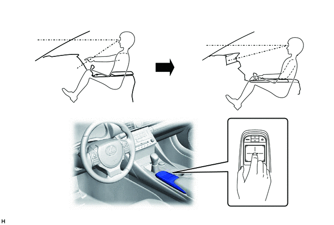
The multi-display is provided at the same height as the combination meter assembly to minimize changes in the driver's line of sight and ensure visibility while driving.
-
Due to the change in the multi-display location, the remote touch is used to ensure operability.
-
A remote touch with a capacitive type touchpad, which allows for intuitive screen operation using finger gestures such as a drag on the pad, is provided. A motor is built into the remote touch to generate vibrations, providing feedback to the user's hand. The vibration allows the user to easily recognize when the selected icons or buttons change, improving ease of operation while driving.
*1 Drag *2 Feedback Vibration *3 The illustrations are examples only. The illustrations may differ from the actual vehicle screens. -
The map database of the navigation system is stored on the microSD card (disc player disc) installed in the radio receiver assembly. A microSD card (disc player disc), which has the latest map database stored, can be purchased to replace the old one and update to the latest map database.
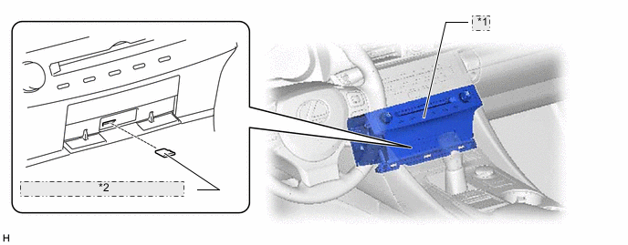
*1 Radio Receiver Assembly *2 microSD Card (Disc Player Disc) -
A fuel consumption screen is provided in consideration of the environment.
-
The navigation system sends navigation information to the combination meter assembly. The user can view a compass display and turn-by-turn directions to the destination on the multi-information display.
-
A multiple display function is provided. Due to this function, a map screen, air conditioning operation screen, and audio screen or vehicle information screen can be displayed on the multi-display assembly simultaneously. Screen layout and displayed items are customizable, and the top screen of each function can be displayed by selecting the corresponding information screen.
-
For high altitude areas, the real terrain map, which enhances the map quality using gradient data in predetermined scales, is displayed.*
*: Models for Europe and G.C.C. countries and destination package for South Africa
-
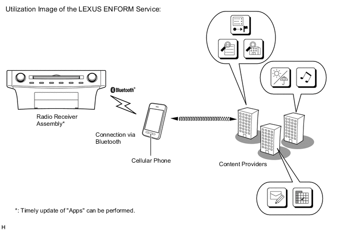
The LEXUS ENFORM service is supported. This service makes it possible to operate specified applications on the navigation system by using Bluetooth to connect the navigation system to a cellular phone with the LEXUS ENFORM application installed.*
*: Models for Australia
-
During route guidance, the user can confirm traffic information, such as congestion and accidents, by using the traffic bar on the map screen. The traffic bar shows information in the area from the current position to the destination or stopover (maximum: 100 km (65 miles)).*
*: Models for Europe and destination packages for South Africa, Southeast Asia and Taiwan
-
Reception of the Transport Protocol Experts Group (TPEG) service, which shows Traffic Flow and Traffic Prediction (TFP) information on the map screen, is available. This service makes it possible to show a route with consideration of TFP information and display the location, fee and status (occupied or vacant) of parking lots.*
*: Models for Europe (Only available in Transport Protocol Experts Group (TPEG) broadcast areas)
-
Connected Services is supported. This allows the user to search for new establishments or establishments that are not registered to the map and set them as a destination. In addition, it is possible to download Point of Interest (POI) and route information that was searched for on the Lexus portal site and set it as a destination or register it to the map.*
*: Models for Europe
-
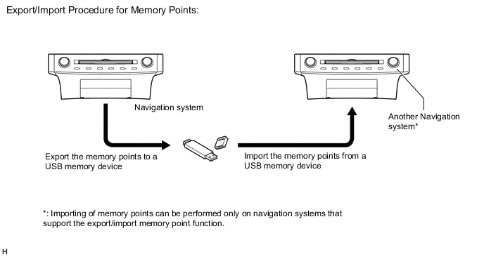
The navigation system supports a function used for the export/import of memory points. This function enables memory point data stored on the radio receiver assembly to be transferred to another navigation system (such as another radio receiver assembly) via a USB memory device.*
*: Except destination package for Southeast Asia
-
The G-BOOK system, which that links the vehicle and G-BOOK communication center, can be used.*
*: Models for China
-
POIs that are searched for using a smartphone application can be sent to the radio receiver assembly via Bluetooth and set as a destination or registered as a memory point.*
*: Models for China and destination package for Hong Kong
-
Google Sync Function (Models for Europe)
-
The Google sync function is supported, enabling the user to view and operate the following Google-provided web services on the navigation system. To use this function it is necessary to access the internet from a tethering-compatible cellular phone or mobile Wi-Fi router, which is connected to the radio receiver assembly via Bluetooth or Wi-Fi communication.
-
Google street view, which shows panoramic images along streets, is available. The street view of the desired location can be downloaded to the radio receiver assembly and displayed on the multi-display.
-
The Panoramio Photo sharing site, which provides photos with location information and comments, is available. Panoramio photos of the desired location can be downloaded to the radio receiver assembly and displayed on the multi-display. Due to location information contained in the photos, it is possible to set a certain point in the displayed photo as a destination.
-
-
-
Wi-Fi Communication (Models for Europe and China)
-
A wireless LAN antenna is integrated into the radio receiver assembly, enabling Wi-Fi communication to user's tethering-compatible cellular phone or mobile Wi-Fi router.
Tech Tips
Wi-Fi communication may be unavailable depending the vehicle conditions, condition of the surroundings such as radio wave conditions around the radio receiver assembly, the distance to the device or device conditions. In addition, during Wi-Fi communication, communication may be cut or become unstable due to the conditions described above.
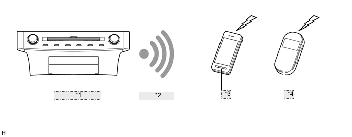
*1 Radio Receiver Assembly *2 Connection Via Wi-Fi *3 Cellular Phone *4 Mobile Wi-Fi Router
-
-
To update the map database partially (Models for China)
-
Download new roads and facility information, which is not included in the map database currently in use, from the G-BOOK center via the internet to partially update the map database.
-
-
-
PRECAUTION
-
microSD Card (Disc Player Disc)
-
When ejecting the microSD card, observe the following precautions to avoid damaging it.
-
The microSD card (disc player disc) stores map data or various programs which are required to operate the navigation system. With the microSD card (disc player disc) removed, the navigation system will not operate properly. Do not remove the microSD card (disc player disc) unless necessary, such as for a map update.
-
Do not insert anything other than a microSD card (disc player disc) into the microSD card slot after removing the microSD card (disc player disc).
-
Do not insert a dusty or dirty microSD card (disc player disc) into the microSD card slot, as it may cause a malfunction.
-
After the microSD card (disc player disc) is inserted, make sure that it is secure in the microSD card slot.
-
-
When handling a microSD card (disc player disc), observe the following precautions. Failure to do so may cause a malfunction.
-
Do not touch the metal contacts of the microSD card (disc player disc) with your fingers or metal objects.

-
Do not bend, drop or strike a microSD card (disc player disc), as it is a precision electronic component and may become damaged.
-
Avoid the following environments when storing a removed microSD card (disc player disc). Failure to do so may cause the microSD card (disc player disc) to malfunction and generate errors in the navigation system.
-
Areas where static electricity or electrical noise is present
-
In extremely hot or humid areas
-
Areas exposed to direct-sunlight
-
Areas where condensation may form
-
Areas where corrosive gases may be generated
-
Do not peel the label on the microSD card or attach a new label or sticker.
-
-
-
Remote Touch
-
The touchpad may not operate properly with gloves or wet hands.
-
Do not spill water on the touchpad. If water is present on the touchpad, the touchpad may not operate properly.
Tech Tips
Once water on the touchpad is wiped away, the touchpad will return to normal. If it still does not operate properly, turn the engine switch off then on (IG) again.
-
Do not place any conductive objects such as coins on the touchpad. They may prevent the touchpad from operating properly.
Tech Tips
Once all conductive objects are removed, the touchpad will return to normal. If it still does not operate properly, turn the engine switch off then on (IG) again.
-
-
-
SPECIFICATION
Component Destination Europe
(including destination package for Russia)
Australia China Multi-display 7.0-inch Wide LCD Navigation Computer Pioneer Gyro Sensor Piezoelectric Ceramic Element Map Data Media microSD Card (Disc Player Disc) microSD card Aisin AW DENSO Language Supported Voice Guidance English, German, French, Spanish, Italian, Portuguese, Dutch, Swedish, Norwegian, Danish, Russian, Finnish, Greek, Polish, Ukrainian, Turkish, Hungarian, Czech, Slovak and Romanian English English, Simplified Chinese and Traditional Chinese Voice Recognition English, German, French, Spanish, Italian, Portuguese, Dutch, Swedish, Danish, Russian, Finnish, Greek, Polish, Turkish and Czech English English, Simplified Chinese and Traditional Chinese Component Destination Hong Kong Taiwan G.C.C. Countries Multi-display 7.0-inch Wide LCD Navigation Computer Pioneer Gyro Sensor Piezoelectric Ceramic Element Map Data Media microSD Card (Disc Player Disc) microSD card DENSO Aisin AW Language Supported Voice Guidance English, Simplified Chinese and Traditional Chinese Taiwanese English and Arabic Voice Recognition Chinese - - Component Destination South Africa Southeast Asia Brazil Multi-display 7.0-inch Wide LCD Navigation Computer Pioneer Gyro Sensor Piezoelectric Ceramic Element Map Data Media microSD Card (Disc Player Disc) microSD card Aisin AW Language Supported Voice Guidance English English, Thai, Malay and Indonesian English, Spanish and Portuguese Voice Recognition English - - -
MAIN FEATURES
-
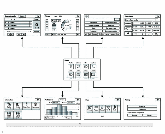
Multi-display
-
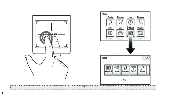
An exclusive hierarchical structure is used for each screen displayed on the multi-display in consideration of the remote touch.
*1 The illustrations shown are examples only. The illustrations may differ from the actual vehicle screens. -
Operating the switches and touchpad of the remote touch changes the screen or selects the buttons and icons.
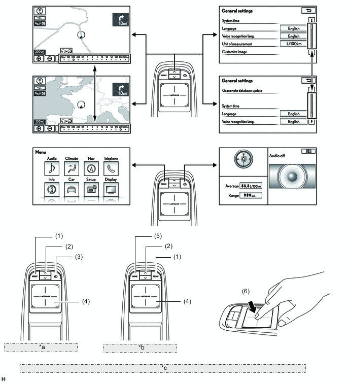
*a Remote Touch (LHD Models) *b Remote Touch (RHD Models) *c The illustrations are examples only. The illustrations may differ from the actual vehicle screens. NO. Switch Function (1) MENU Displays the menu screen. (2) Seesaw Switch
-
Changes the map scale.
-
Scrolls the list screen.
(3) Home Mark*1 or HOME*2 Displays the present home screen. (4) Touchpad Moves the pointer on the screen. (5) HOME Displays the present home screen. (6) Enter
(Press the touchpad)
Selects the icon and buttons currently selected with the pointer. *1: Models for Europe
*2: Except models for Europe
-
-
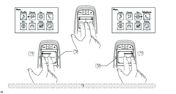
On the touchpad, the pointer or cursor can be moved with a drag of a finger. Other screen operations are as follows.
-
The map screen and list screens can be scrolled by performing a flick operation on the touchpad.
Tech Tips
Flick operation on the map screen is only available during full screen display.
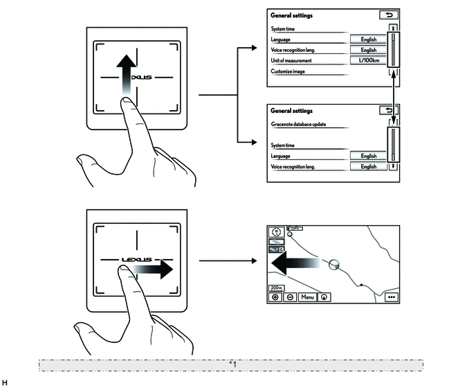
Flick Operation *1 The illustrations are examples only. The illustrations may differ from the actual vehicle screens. Touchpad Operation Function Flick
-
Scrolls the map screen.*
-
Scrolls a list screen.
*: Only available on a full screen display
-
-
The map scale can be changed by performing a pinch operation on the touchpad.
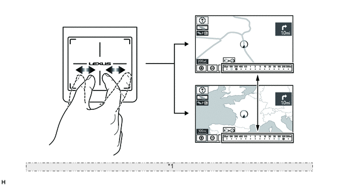
Pinch Operation *1 The illustrations are examples only. The illustrations may differ from the actual vehicle screens. Touchpad Operation Function Pinch Zooms the map in and out. -
The icons and buttons currently highlighted on the screen can be selected by pressing the touchpad. A double-tap is also available.
Double-tap Operation *1 The illustrations are examples only. The illustrations may differ from the actual vehicle screens. Touchpad Operation Function Double-tap Selects the icons or buttons currently highlighted with the pointer.
-
-
-
Connected Services
-
The following services are available by accessing the Lexus portal site from a tethering compatible cellular phone or mobile Wi-Fi router, which is connected to the radio receiver assembly via Bluetooth or Wi-Fi communication.
-
To use these connected services, a Bluetooth or Wi-Fi connection and a portal account are required.
-
To get a portal account, access the Lexus portal site (URL:www.my.lexus.eu).
Contents Outline Online search New establishments, such as restaurants and bars, that are not registered in the navigation system can be set as a destination. Importing memory points and routes Downloading via a cellular phone or mobile Wi-Fi router Memory points and routes that were searched for using a personal computer can be set as a destination and can be registered as memory points. Downloading from a USB memory device 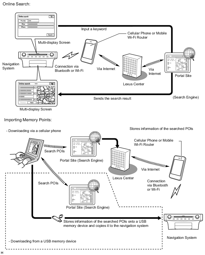
-
-
Export/Import Memory Point Function
-
Memory point data stored in the radio receiver assembly can be transferred to another navigation system, enabling information sharing.
-
-
LEXUS ENFORM Service
-
The LEXUS ENFORM service makes it possible to operate specified applications on the multi-display assembly by using Bluetooth to connect the navigation system to a cellular phone with the LEXUS ENFORM application installed.
-
The LEXUS ENFORM service enables communication between the navigation system, application server and content provider utilizing the LEXUS ENFORM application installed on a cellular phone.
-
-
To update the map database partially
-
Download new roads and facility information from the G-BOOK center to the radio receiver assembly via the internet using the telematics transceiver (data communication module)*1, cellular phone*2, tethering-compatible cellular phone*2 or mobile Wi-Fi router*2 to partially update the map database.
*1: Models with telematics transceiver (data communication module)
*2: Models without telematics transceiver (data communication module)
-
When the map database is partially updated, the following content can be updated:
Updatable map database Update range Road Freeways and urban freeways All regions of the country National roads, provincial roads, county roads and rural roads and streets
-
Default: Within a 20 km radius of the vehicle (10 km radius when on a local street)
-
With destination being set: Within a 20 km radius of the vehicle (10 km radius when on a local street)
Facility information Facilities on freeways and urban freeways All regions of the country 3D landmarks level of major facilities Tech Tips
-
City maps, voice guidance data and facility general information cannot be updated.
-
The partial update service of map database is only available for 2 years from the date of the new car registration. If a microSD card, which has the latest map database stored, is purchased and the map database is updated, the service will be available for 2 years from the date of update.
-
The partial update service is available for free before the availability period ends, with the exception of the following costs:
-
G-BOOK system basic charge (if the G-BOOK system contract was created, for models with telematics transceiver (data communication module))
-
Internet communication charge (for models without telematics transceiver (data communication module))
-
If the update data is large, it may take a few hours to partially update the map database.
-
If other operations related to the navigation system are performed while partially updating the map database, it may take longer.
-
-
-
Voice Recognition System
-
When the voice recognition system starts operating, the commands that the system is able to recognize are displayed on the multi-display.
-
In the aim of enabling the user to operate the system with minimal spoken words, the recognition command screen is designed to show not only sample spoken words for short-cut commands, but also tabs for the major functions such as Audio, Navi and Phone. When a tab is selected, a detailed list of the voice recognition commands will be displayed for the corresponding function. (Models for Australia)
Tech Tips
Other functions still can be operated by voice recognition commands when a tab is selected for a specific function.
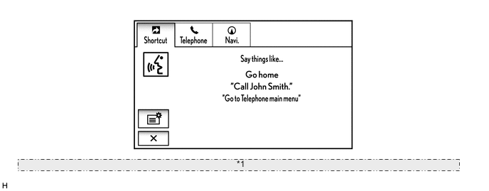
*1 The illustration shown is an examples only. The illustration may differ from the actual vehicle screens.
-
-
The main functions of the multi-display are listed below.
Function Outline Navigation System Through the use of the Global Positioning System (GPS) and map data which is stored on a microSD card, the navigation system analyzes the position of the vehicle and indicates the position on the map that is displayed on the screen.
In addition, it is possible to use the system to register memory points and navigate to a destination.
Audio/Video System Serves as the display and controls for the following:
-
Radio operation
-
CD/DVD player operation
-
Sound Library operation (Models for China)
-
Bluetooth-compatible portable player operation
-
iPod / iPhone operation
-
USB memory device operation
-
Portable audio player operation (AUX type)
Air Conditioning System Operation and control of the air conditioning system can be performed through the use of the automatic air conditioning switches displayed on the multi-display. Hands-free System When a Bluetooth-compatible cellular phone is registered to the navigation system, the driver can make and receive calls or talk hands-free on the cellular phone by operating the switches on the screen/steering pad. Speech Command System (Models with Voice Recognition System) Operates the navigation, audio, and hands-free systems based on voice commands. Parking Assist Monitor System (Models with Parking Assist Monitor System) Displays a view of the area behind the vehicle that is captured by the rear television camera mounted on the luggage compartment door when the shift lever is moved to R. LEXUS Parking Assist-sensor System (Models with LEXUS Parking Assist-sensor System) Detects obstacles and displays information on the multi-display to inform the driver. Others Fuel Consumption Screen Fuel consumption information such as average fuel consumption per minute, current fuel consumption per minute and past fuel consumption record is displayed. Remote Touch Setting The following settings of each function of the remote touch can be changed:
-
Pointer sound
-
Pointer sound volume
-
Feedback force
Maintenance Information The maintenance information function can be used to inform the driver of the inspection or replacement timing of the following items based on the calendar function and distance driven.
-
ENGINE OIL: Replace engine oil
-
OIL FILTER: Replace engine oil filter
-
ROTATION: Rotate tires
-
TYRE/Tires: Replace tires
-
BATTERY: Replace battery
-
BRAKE PAD: Replace brake pads
-
WIPERS: Replace wiper blades
-
LLC/Coolant: Replace engine coolant
-
BRAKE OIL: Replace brake fluid
-
ATF/Trans. Fluid: Replace ATF
-
SERVICE: Scheduled maintenance
-
AIR FILTER: Replace air filter
-
PERSONAL: New information items can be created separately from the provided items
Language Select (Models for Europe, China and G.C.C. Countries and Destination Packages for Hong Kong, Brazil and Southeast Asia) The language of the screen buttons, pop-up messages and the voice guidance can be changed. Button Color Setting The button color can be changed. Screen Setting This enables automatic return to the navigation screen from the audio screen. Keyboard Layout The keyboard layout can be changed. Delete Personal Data Deletes or returns registered or changed personal settings to their default conditions. For example:
-
General settings
-
Navigation settings
-
Audio settings
-
Telephone/Phone settings
-
Connected services settings (Models for Europe)
-
LEXUS ENFORM settings (Models for Australia)
-
G-BOOK settings (Models for China)
Screen Adjustment The brightness or contrast of the screen can be adjusted to suit the brightness of the surroundings. Map Database Update
-
Replace the old microSD card with a microSD card which has the latest map database stored to entirely update the map database.
-
Download information such as new roads to partially update the map database. (Models for China)
Diagnosis This menu contains the following items:
-
Failure Diagnosis
-
System Check
-
SD Check
-
DCM Check (Models for China with Telematics Transceiver Connection Type G-BOOK System)
-
Diagnosis Recorder
-
HDD Check (Models for China)
-
Function Check / Setting
-
Panel & Steering Switch
-
Remote Touch Switch
-
Microphone Check
-
System Sensors Check
-
Vehicle Signal
-
Sound Library Setting (Models for China)
-
HF Voice Quality Setting
-
Camera Setting (Models with Parking Assist Monitor System)
-
DTV Reception Check (Destination Package for Brazil)
-
DAB Reception Check (Models with Digital Audio Broadcast (DAB) Tuner)
-
Service Information
-
G-BOOK Info for Contract (Models for China with Telematics Transceiver Connection Type G-BOOK System)
-
DCM Information (Models for China with Telematics Transceiver Connection Type G-BOOK System)
-
Emergency Call History (Models for China with Telematics Transceiver Connection Type G-BOOK System)
-
Security History (Models for China with Telematics Transceiver Connection Type G-BOOK System)
-
Program Update
-
Version Information
-
Memory point backup (Except Destination Package for Southeast Asia)
-
Product Information
-
-