NAVIGATION SYSTEM / MULTI INFORMATION SYSTEM
-
FUNCTION OF MAIN COMPONENTS
Component Function Navigation Receiver Assembly*1 Receives and processes the data that is input from various components, displays various pieces of information and operating conditions on the screen, and provides voice guidance. Radio and Display Receiver Assembly*2
- Extension Box (Navigation ECU)
Navigation Antenna Assembly Receives signals from the GPS satellites and transmits them to the navigation receiver assembly or the radio and display receiver assembly. Combination Meter Assembly Transmits vehicle speed signals to the navigation receiver assembly or the radio and display receiver assembly. Steering Pad Switch Assembly Enables the driver to operate the navigation system from the steering pad switches. Map Light Assembly
- Telephone Microphone Assembly
Transmits voice signals to the navigation receiver assembly or the radio and display receiver assembly. Back-up Light Switch Assembly*3 Transmits the on/off signal of the back-up light switch assembly to the navigation receiver assembly or the radio and display receiver assembly. Park/Neutral Position Switch Assembly*4 Transmits the R position signal to the navigation receiver assembly or the radio and display receiver assembly. Rear Television Camera Assembly*5
-
Captures the view behind the vehicle and transmits the image to the parking assist ECU or the navigation receiver assembly or radio and display receiver assembly.
-
Sends signals about parking assist guidelines calculated based on signals from the steering sensor to the navigation receiver assembly or the radio and display receiver assembly via CAN communication.* 6
No. 1 Stereo Jack Adapter Assembly Transmits information about the portable audio player connected to the USB port or AUX port to the navigation receiver assembly or radio and display receiver assembly. Television Display Assembly*7
-
Displays the navigation screen (information).
-
Receives signals from the remote controller (television switch and volume assembly).
-
*1: Except models for Europe
-
*2: Models for Europe
-
*3: Models with manual transmission
-
*4: Models with automatic transmission
-
*5: Models with rear television camera assembly
-
*6 Models for Australia
-
*7 Models with Rear Seat Entertainment system (RSE)
-
-
FUNCTION
-
Navigation Screen
-
The navigation computer calculates the present position and direction of travel, then determines a route and calculates the driving distance based on the following information sources:
-
Map data in the microSD card, extension box or built-in memory
-
Global Positioning System (GPS) satellites
-
Built-in gyro sensor
-
Vehicle speed signal
-
Reverse signal
-
Parking brake signal
-
Radio Data System Traffic Message Channel (RDS-TMC) signal
Models with unit of Pioneer Function Outline Map Display Current Position Displays the current position when the navigation system starts. Moving (Scrolling) Map Moves the map to the user's desired location. Switching Map Orientation Switches the screen between 2D and 3D views. Street View Displays different modes on a screen that is split into 2 views. One-way Street Display Displays the one-way street mark. Changing Map Scale Changes the map scale between 10 m and 2000 km. Text Zoom Zooms in on the text of location names and POIs displayed on the map screen. Registering Scale Scales for each map in accordance with the display method. The registered scale is displayed on the map screen when the HOME button is pressed. Setting Logo Display Displays logos of various POIs on the map. Traffic Information (RTIC) Displays traffic information such as traffic congestion, accidents and road closures on the map. Destination Search By Map Destinations can be found on the map. By Address Searches for a destination by using the destination address entered. By Home Searches for a route to the user's home. By Favorites Selects the destination from the locations to search for the destination. By History Selects the destination from the locations searched in the past to search for the destination. By Name Searches for the destination by using the destination name entered. By Near Here Specifies the category of POIs around the current location to search for the destination. By Near Destination Specifies the category of POIs around the destination to search for the destination. By Near City Specifies the city, and then the category of POIs around the city to search for the destination. By Coordinates Specifies the longitude and latitude to search for the destination. By Special Favorites If the user has special favorites already registered, the destination can be found by specifying one of the favorites. By Telephone Number The user can find the destination by telephone number. Route Guidance Multiple Destination Setting Sets multiple destinations:
-
Adding waypoint: A waypoint can be added to the route and used during route guidance.
-
Adding destination: A new destination can be added before or after the currently set destination(s).
-
Reordering destination: The arrival order of the multiple destinations that are set can be changed.
-
Deleting destination: A destination can be deleted.
Road Preference The user can choose whether the system uses the following items on the way to the destination:
-
Route display
-
Route search condition/criteria display
-
Distance
-
Travel time
Approaching Intersection Displays the guidance screen of the intersection. Approaching Motorway Exit or Junction Displays the guidance screen of the motorway exit or junction. Approaching a Roundabout When the user approaches a roundabout on the route, the roundabout guidance appears on the right pane. Voice Guidance During route guidance, the following types of voice guidance are provided:
-
Continue driving straight guidance
-
Right/left turn guidance
-
U-turn guidance
-
Road branching guidance
-
Destination approach/arrival guidance and so on
Editing Route The user can edit a route by confirming the set route, specifying waypoints, etc. Models with Unit of FUJITSU TEN or Panasonic (Except Models without Extension Box) Function Outline Map Display Taillight-interlocked Map Color Change Changes the color of the map screen when the taillights are turned on. North Up/Heading Up
-
If North Up is selected, regardless of the direction of vehicle travel, north is always up.
-
If Heading Up is selected, the direction of vehicle travel is always up.
3D Display Displays a 3-dimensional (3D) view of the map. Zoom in/Zoom out Change the area of the map displayed on the screen. Tilt up/Tilt down In 3D mode, you can change the vertical display angle of the map. Rotate left/Rotate right Changes the horizontal display angle of the map. Street Name Indication on Scrolled Map Displays the street name and city name even when the map screen is being scrolled. Road Number Sign Board Displays the road number on the map. Point of Interest Display Displays selected types of points of interest as marks on the map. Multiple Display Function Displays different modes on a screen that is split into 2 or 3 views. Route Guidance Demonstration Demonstrates the route guidance to the destination. Route Trace Displays a list of all trip logs, whether they were saved by the user upon reaching the destination or whether they were saved automatically. RDS-TMC Display Displays RDS-TMC icons, arrows, pop-up messages and indicators when the RDS-TMC service is being received. Help Nearby Screen The user can search for the following services around the current position of the vehicle or the latest confirmed position:
-
Car Repair Around Here: Vehicle repairs/Road-side assistance services
-
Health Around Here: Hospitals/Emergency services
-
Police Around Here: Police stations
-
Petrol Station Around Here: Gas stations
Destination Search Preset Destination Memory Search Sets a pre-registered point as a destination point while driving. Address Search Information can be entered in the order of: area, town name, street name and house number. Hybrid Point of Interest Narrows the search by names of the point of interest, category and areas. Previous Destination Search Stores the coordinates, names, and date of up to 100 locations that have been set as destinations. Online Database Destination Search A point searched for using the Toyota Link apps content can be set as a destination. Point of Interest Search A destination can be set in 3 ways:
-
The name of a POI can be entered and then searched for from city or category.
-
A POI category can be selected to search for a POI near the present location, along the current route, near the city center or near the destination.
-
A POI can be searched for by its phone number.
Map Search A destination can be set by scrolling the cursor on the map. Memory Point Search Sets a destination from the registered memory point. Intersection or Motorway Entrance/Exit Search A destination can be set in 2 ways:
-
By specifying 2 streets, the point at which they intersect is set as the destination point.
-
Searches for the destination by the name of the street that connects to a motorway entrance or exit.
Address Book (Memory Point) Search Sets a destination from the registered address book (memory point). Coordinate Search A destination can be input by entering its coordinates. Route Search Multiple Destination Setting Sets multiple destinations. It can also rearrange the sequence of the destinations. Multiple Route Search Searches for multiple routes. Search Condition Designation Searches for quick, alternate and short routes. Reordering Destinations Changes the order of destinations when more than one destination is selected. Detour Search Changes the route to detour around a section of the route. Avoidance Area Searches for a route that avoids a designated area. Auto Avoid Traffic Search Automatically changes to another route to avoid heavy congestion. Guidance Voice Guidance Provides voice guidance about the distance and the direction of travel to a destination point based on road conditions and vehicle speed. Next Turn Guidance Provides guidance about the distance to the next turn and indicates the direction of the turn using an arrow. Motorway Mode Display Displays the distance to the next junction and exit, or POIs in the area around a motorway exit. Motorway Exit or Junction Display When the vehicle approaches an exit or junction, the motorway guidance screen will be displayed. Motorway Direction of Travel Display Displays the direction of travel to take on the motorway. Real Motorway Junction Display Displays the junction and signage in 3D in the area around a major junction while driving. Intersection Zoom-in Display Zooms in the image when approaching an intersection. Turn List Display Displays a turn list on the right side of the 2-screen display. Arrow (Turn-by-Turn) Display Displays the direction of the next turn and the distance to the turn on the right side of the 2- screen display. Lane List Display Displays a lane list on the right side of the 2-screen display. Distance-to-destination Display Displays the distance from the present location to the destination. Driver Support Information icon Display Displays warning icons when the vehicle approaches the area, such as a school zone, railway crossing or high accident zone. Route Information Bar Display Displays the following information:
-
Street name of the current location
-
Distance and travel time to the destination
-
Distance to the destination and estimated time of arrival
-
Distance to the destination and an arrow facing the destination (when off the route during the guidance)
Traffic Bar Display Displays traffic information of congestions or accidents on the route using the traffic bar (except models for G.C.C. countries). Others Voice Recognition Recognizes pre-programmed system commands spoken to operate the navigation system. Map Coverage Information Display Displays the map area that is stored on the microSD card. Models with Unit of Panasonic (Models with Extension Box) Function Outline Map Display Taillight-interlocked Map Color Change Changes the color of the map screen when the taillights are turned on. North Up/Heading Up
-
If North Up is selected, regardless of the direction of vehicle travel, north is always up.
-
If Heading Up is selected, the direction of vehicle travel is always up.
3D Display Displays a 3-dimensional (3D) view of the map. Zoom in/Zoom out Change the area of the map displayed on the screen. Street Name Indication on Scrolled Map Displays the street name and city name even when the map screen is being scrolled. Road Number Sign Board Displays the road number on the map. Point of Interest Display Displays selected types of points of interest as marks on the map. RDS-TMC Display Displays RDS-TMC icons, arrows, popup messages and indicators when RDS-TMC service is being received. Destination Search Preset Destination Memory Search Sets a pre-registered point as a destination point while driving. Address Search Information can be entered in the order of: area, town name, street name and house number. Previous Destination Search Stores the coordinates, names, and date of up to 100 locations that have been set as destinations. Online Database Destination Search A point searched for using the Toyota Link apps content can be set as a destination. Point of Interest Search A destination can be set in 3 ways:
-
The name of a POI can be entered and then searched for from city or category.
-
A POI category can be selected to search for a POI near the present location, along the current route, near the city center or near the destination.
Map Search A destination can be set by scrolling the cursor on the map. Address Book (Memory Point) Search Sets a destination from the registered Address Book (Memory Point). Coordinate Search A destination can be input by entering its coordinates. Route Search Multiple Destination Setting Sets multiple destinations. It can also rearrange the sequence of the destinations. Search Condition Designation Searches for the fast, short and ecological routes. Reordering Destinations Changes the order of destinations when more than one destination is selected. Detour Search Changes the route to detour around a section of the route. Avoidance Area Searches for a route that avoids a designated area. Auto Avoid Traffic Search Automatically changes to another route to avoid heavy congestion. Guidance Voice Guidance Provides voice guidance about the distance and the direction of travel to a destination point based on road conditions and vehicle speed. Next Turn Guidance Provides guidance about the distance to the next turn and indicates the direction of the turn using an arrow. Motorway Exit or Junction Display When the vehicle approaches an exit or junction, the motorway guidance screen will be displayed. Distance-to-destination Display Displays the distance from the present location to the destination. Route Information Bar Display Displays the following information:
-
Street name of the current location
-
Distance and travel time to the destination
-
Distance to the destination and estimated time of arrival
-
Distance to the destination and an arrow facing the destination (when off the route during the guidance)
Traffic Bar Display Displays traffic information of congestions or accidents on the route using the traffic bar. Others Voice Recognition Recognizes pre-programmed system commands spoken to operate the navigation system. -
-
The fuel consumption screen is displayed as illustrated below. This screen has the display functions listed below:
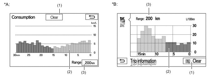
Text in Illustration *A Models without Extension Box *B Models with Extension Box Item Outline (1) Clear Switch Clears all past information. (2) Average Fuel Consumption per Minute
-
Displays the value that has been calculated by the combination meter assembly, which is based on the driven distance and the volume of fuel consumed (fuel injection signal), since the engine switch was turned on (IG).
-
Displays the average fuel consumption for the last minute or since clear was last selected.
(3) Range Displays the approximate drivable distance. -
-
-
-
DIAGNOSIS
-
For details on the procedure required to enter the Service Menu screen, refer to the Repair Manual.
-