NEW FEATURES
-
DESCRIPTION
-
The 13CY model navigation system is used.
Specification Display
-
9.0 inch Wide Video Graphics Array (WVGA)
-
PANASONIC
Navigation ECU Manufacturer PIONEER Gyro Sensor Piezoelectric Ceramic Element Map Data Media microSD Card microSD Card DENSO*1, AISIN AW*2 Voice Guidance Supported Languages English, German*3, French*3, Spanish*3, Italian*3, Portuguese*3, Dutch*3, Swedish*3, Norwegian*3, Danish*3, Russian*3, Finnish*3, Greek*3, Polish*3, Ukrainian*3, Turkish*3, Hungarian*3, Czech*3, Slovak*3, Romanian*3, Arabic*4 and Chinese*5 Voice Recognition Supported Languages*6 English, German*3, French*3, Spanish*3, Italian*3, Portuguese*3, Dutch*3, Swedish*3, Danish*3, Russian*3, Finnish*3, Greek*3, Polish*3, Turkish*3, Czech*3 and Chinese*5 *1: Models for Australia and China
*2: Except models for Australia and China
*3: Models for Europe
*4: Models for G.C.C. Countries
*5: Models for China
*6: Models with voice recognition system
-
-
The map database of the navigation system is stored in the microSD card in the multi-media module receiver assembly. To update the map database, purchase a new microSD card with the latest map database and replace the old microSD card.
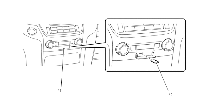
*1 Multi-media Module Receiver Assembly *2 microSD Card (Disc Player Disc) -
A fuel consumption screen is provided in consideration of the environment.
-
During route guidance, the user can confirm traffic information, such as congestions and accidents, displayed on the traffic bar on the map screen. The traffic bar shows information in the area from the current position to the destination or stopover (100 km (65 miles) at the maximum). (Models for Europe)
-
Transport Protocol Experts Group (TPEG) service that shows Traffic Flow and Traffic Prediction (TFP) information on the map screen is available. This service makes it possible to show a route with consideration of TFP information and display the location, fee and status (occupied or vacant) of the parking lots. (Models for Europe)
-
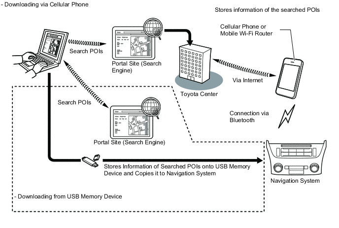
A connected service is supported. This allows the user to search new establishments or establishments that are not registered in a map and set it as a destination. In addition, it is possible to download the Point of Interest (POI) and route information that is searched on the Toyota portal site and set it as a destination or register it to the map. (Models for Europe)
-
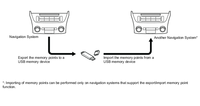
The navigation system supports a function used for the export/import of memory points. This function enables memory point data stored on the multi-media module receiver assembly to be transferred to another navigation system (such as another multi-media module receiver assembly) via a USB memory device.
-
The user can confirm the Bluetooth connection status, signal strength and remaining battery level of a cellular phone which is connected by Bluetooth, using the status bar displayed on the screen. The status bar is displayed in all modes.
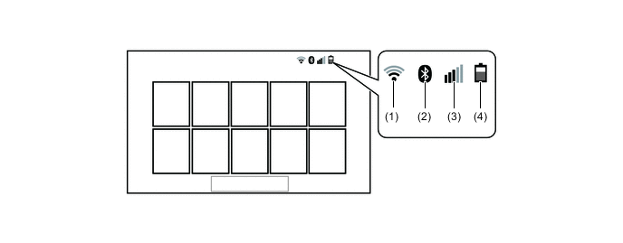
Item Outline (1) Wi-Fi connection status (Models for Europe and China) Displays the Wi-Fi connection status between the audio head unit and a tethering-compatible cellular phone or mobile Wi-Fi router. (2) Bluetooth connection status Displays the Bluetooth connection status between the audio head unit and cellular phone. (3) Cellular phone signal strength* Displays the signal strength of the Bluetooth connected cellular phone. (4) Cellular phone battery level* Displays the battery level of the Bluetooth connected cellular phone. Tech Tips
*: May not be displayed depending on the Bluetooth specifications and profiles of the cellular phone.
-
-
Google Sync Function (Models for Europe)
-
The Google sync function is supported, enabling the user to view and operate the following Google-provided web services on the navigation system. It is required to access the internet from a tethering-compatible cellular phone or mobile Wi-Fi router, which is connected to the multi-media module receiver assembly via Bluetooth or Wi-Fi communication.
-
Google street view shows panoramic images along streets. The street view of the desired location can be downloaded to the multi-media module receiver assembly and displayed on the multi-display assembly.
-
Panoramio Photo sharing site (photos are provided with location information and comments). The panoramio photos of the desired location can be downloaded to the multimedia module receiver assembly and displayed on the multi-display assembly. Due to location information contained in the photos, it is possible to set a certain point in the displayed photo as a destination.
-
-
Wi-Fi Communication (Models for Europe and China)
-
A wireless LAN antenna is integrated in the multi-media module receiver assembly, enabling Wi-Fi communication to user's tethering-compatible cellular phone or mobile Wi-Fi router.
Tech Tips
The Wi-Fi communication may be unavailable according to the vehicle conditions, surrounding conditions such as radio wave conditions around the multi-media module receiver assembly, the distance to the device or device conditions. In addition, during Wi-Fi communication, the communication may be cut or become unstable due to the conditions described above.
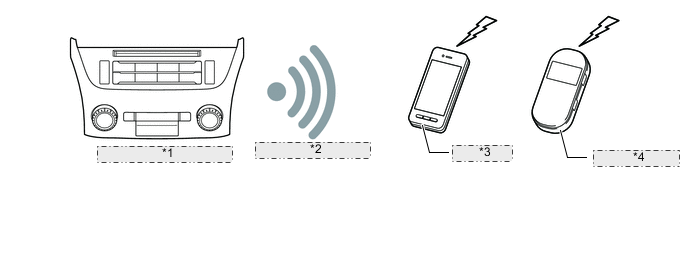
*1 Multi-media Module Receiver Assembly *2 Connection via Wi-Fi *3 Cellular Phone *4 Mobile Wi-Fi Router
-
-
Connected Services (Models for Europe)
-
The following services are available by accessing the Toyota portal site from a tethering compatible cellular phone or mobile Wi-Fi router, which is connected to the multi-media module receiver assembly via Bluetooth or Wi-Fi communication.
-
To use these connected services, Bluetooth or Wi-Fi settings are required and a portal account are required.
-
To get a portal account, access the Toyota portal site (URL: www.my.toyota.eu).
Contents Outline Online search New establishments, such as restaurants and bars, that are not registered in the navigation system can be set as a destination. Importing memory points and routes Downloading via a cellular phone or mobile Wi-Fi router Memory points and routes that were searched for using a personal computer can be set as a destination and can be registered as memory points. Downloading from a USB memory device Figure 1. Online Search
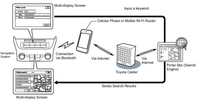
Figure 2. Importing Memory Points
-
-
Export/Import Memory Point Function
-
Memory point data stored in the multi-media module receiver assembly can be transferred to another navigation system, enabling information sharing.
-
-
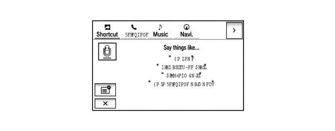
Voice Recognition System
-
When the voice recognition system starts operating, the commands that the system is able to recognize are displayed on the multi-display assembly.
-
To allow the user to operate the system with minimal spoken words, the recognition command screen is designed to show not only sample spoken words for shortcut commands, but also tabs for the major functions such as Music, Navi and Telephone. When a tab is selected, a detailed list of the voice recognition commands will be displayed for the corresponding function.
Tech Tips
Other functions can still be operated by voice recognition commands when a tab is selected for a specific function.
-
-
SYSTEM DIAGRAM
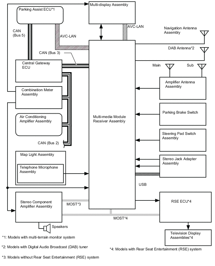
*1: Models with multi-terrain monitor system
*2: Models with Digital Audio Broadcast (DAB) Tuner
*3: Models without Rear Seat Entertainment (RSE) system
*4: Models with Rear Seat Entertainment (RSE) system
-
LAYOUT OF MAIN COMPONENTS
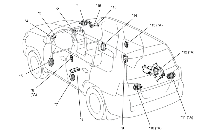
*A Models with 14-speaker System - - *1 Map Light Assembly
-
Telephone Microphone Assembly
*2 Front No. 4 Speaker Assembly *3 Front No. 3 Speaker Assembly LH *4 Front No. 2 Speaker Assembly LH *5 Front No. 1 Speaker Assembly LH *6 Rear No. 3 Speaker Assembly LH *7 Rear Speaker Set LH *8 Stereo Component Amplifier Assembly *9 Rear Speaker Set RH *10 Rear Header Speaker Assembly LH *11 Rear Header Speaker Assembly RH *12 No. 1 with Box Speaker Assembly *13 Rear No. 3 Speaker Assembly RH *14 Front No. 1 Speaker Assembly RH *15 Front No. 3 Speaker Assembly RH *16 Front No. 2 Speaker Assembly RH 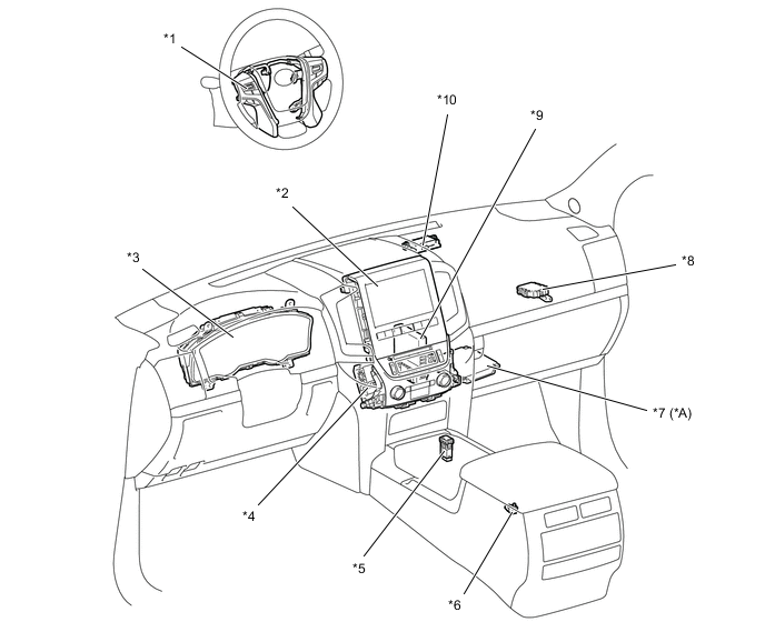
*A Models with Multi-terrain Monitor System - - *1 Steering Pad Switch Assembly *2 Multi-display Assembly *3 Combination Meter Assembly *4 Multi-media Module Receiver Assembly *5 Stereo Jack Adapter Assembly *6 Parking Brake Switch *7 Parking Assist ECU *8 Central Gateway ECU *9 Air Conditioning Amplifier Assembly *10 Navigation Antenna Assembly 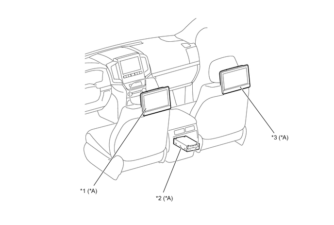
*A Models with Rear Seat Entertainment (RSE) System - - *1 Television Display Assembly LH *2 RSE ECU *3 Television Display Assembly RH - - -
-
FUNCTION
-
A 9.0-inch Video Graphics Array (VGA) monitor is used for the multi-display assembly.
*A Models for Europe *B Models for Australia -
The main functions of the multi-display are shown below:
Main Function Outline Navigation System Through the use of the Global Positioning System (GPS) and map data which is stored on a microSD card, the navigation system analyzes the position of the vehicle and indicates the position on the map that is displayed on the screen. In addition, it is possible to use the system to register memory points and navigate to a destination. Audio/Video System Serves as the display and controls for the following operations:
-
Radio operation
-
CD/DVD player operation
-
Sound Library operation (Models for China)
-
Bluetooth-compatible portable player operation
-
iPod/iPhone operation
-
USB memory operation (USB type)
-
Portable audio player operation (AUX type)
Hands-free System When a Bluetooth-compatible cellular phone is registered to the navigation system, the driver can make and receive calls or talk hands-free on the cellular phone by operating the switches on the screen/steering pad switch assembly. Speech Command System (Models with Voice Recognition System) Operates the navigation and audio systems based on voice commands. Air Conditioning System Operation and control of a part of the air conditioning system can be performed through the use of the automatic air conditioning switches displayed on the multi-display assembly. Parking Assist Monitor System (Models with Multi-terrain Monitor System), Monitor System Displays a view of the area behind the vehicle that is captured by the television camera mounted on the back door when the shift lever is moved to R. Toyota Parking Assist-sensor System (Models with Toyota Parking Assist-sensor System) Detects obstacles and displays information on the multi-display assembly to inform the user. Others Fuel Consumption Screen Fuel consumption information such as average fuel consumption per minute, current fuel consumption per minute and past fuel consumption record is displayed. Maintenance Information The maintenance information function can be used to inform the driver of the inspection or replacement timing of the following items based on the calendar function and distance driven.
-
ENGINE OIL: Replace engine oil
-
OIL FILTER: Replace engine oil filter
-
ROTATION: Rotate tires
-
TYRE/Tires: Replace tires
-
BATTERY: Replace auxiliary battery
-
BRAKE PAD: Replace brake pads
-
WIPERS: Replace wiper blades
-
LLC: Replace engine coolant
-
BRAKE OIL: Replace brake fluid
-
AT FLUID / Trans. Fluid: Replace ATF
-
SERVICE: Scheduled maintenance
-
AIR FILTER: Replace air filter
-
PERSONAL: New information items can be created separately from the provided items
Language Select The language of the screen buttons, pop-up messages and the voice guidance can be changed. Button Color Setting The button color can be changed. Screen Setting This enables automatic return to the navigation screen from the audio screen. Keyboard Layout The keyboard layout can be changed. Delete Personal Data Registered or changed personal settings will be deleted or returned to their default conditions. For example:
-
General settings
-
Navigation settings
-
Audio settings
-
Telephone/Phone settings
-
Connected service settings (Models for Europe)
Screen Adjustment The brightness or contrast of the screen can be adjusted to suit the brightness of the surroundings. Map Database Update Replace the old microSD card with an microSD card, which stores the latest map database to entirely update the map database. Diagnosis This menu contains the following items:
-
Failure Diagnosis
-
System Check
-
SD Check
-
Diagnosis Recorder
-
HDD Check (Models for China)
-
Function Check/Setting
-
Panel and Steering Switch
-
Microphone Check
-
System Sensors Check
-
Vehicle Signal
-
Sound Library Setting (Models for China)
-
HF Voice Quality Setting
-
Camera Setting
-
DAB Reception Check (Models with Digital Audio Broadcast (DAB) Tuner)
-
Service Information
-
Program Update
-
Version Information
-
Memory point backup
-
Product Information
-
-
-
Navigation Screen
-
The navigation computer calculates the present position and direction of travel, then determines a route and calculates the driving distance based on the following information sources:
-
Map data in the microSD card (disc player disc)
-
Global Positioning System (GPS) satellites
-
Built-in gyro sensor
-
Vehicle speed signal
-
Reverse signal
-
Parking brake signal
-
Radio Data System Traffic Message Channel (RDS-TMC) and Transport Protocol Experts Group (TPEG) signal (Models for Europe)
-
Radio Data System Traffic Message Channel (RDS-TMC) signal (Except models for Europe and China)
-
Real-time Traffic Information of China (RTIC) signal (Models for China)
Item Function Map Display Taillight-interlocked Map Color Change Changes the color of the map screen that is displayed when the taillights are turned on. North Up/Heading Up
-
If North Up is selected, regardless of the direction of vehicle travel, north is always up.
-
If Heading Up is selected, the direction of vehicle travel is always up.
3D Display Displays a 3-dimensional (3D) view of the map. 2D and 3D City Map*1, *3, *5
-
Displays some areas of major cities with a 3-dimensional (2D and 3D) city map when the map scale is set to 50 m or less.
-
Always displayed in Heading Up mode.
3D City Model Map*2, *4
-
Displays some areas of major cities with a 3-dimensional (3D) city model map when the map scale is set to 100 m or less.
-
Always displayed in Heading Up mode.
Multi-step Scale Display Changes the map scale in 14 steps.*1, *3, *5 Changes the map scale in 13 steps.*2, *4 Direct Scale Change Directly touch and displays the map scale. Street Name Indication on Scrolled Map Displays the street name and city name even when the map screen is being scrolled. Footprint Map*4 Displays a major city in a scale of 25 m. Stepless Scale Display Changes the scale of the map from the basic 14 steps to an even finer range of scales.*1, *3, *4, *5 Changes the scale of the map from the basic 13 steps to an even finer range of scales.*2 Road Number Sign Board Displays the road number on the map. Point of Interest Display Displays selected types of points of interest as marks on the map. Multiple Display Function Displays different screens on a screen that is split into 3 views or 2 views. Compass Mode Screen*1, *3, *4, *5 Displays the direction of travel and detailed data of the present location. Route Guidance Demonstration Demonstrates the route guidance to the destination. Route Trace*4
-
Stores up to the last 200 km (124 miles) of a traveled route and retraces the route on the display.
-
Available when the map scale is set to 30 miles (50 km) or less.
Route Trace Registration*1, *3, *5
-
A traveled route (up to 200 km (124 miles)) can be stored with a name by setting a start point and end point.
-
The stored traveled route can be displayed on the map screen.
-
Available when the map scale is set to 50 km (30 miles) or less.
RDS-TMC and TPEG Service Information Display*1 Displays the traffic icons, arrows and indicators when RDS-TMC or TPEG service information is being received. RDS-TMC Display*3, *5 Displays RDS-TMC icons, arrows, popup messages and indicators when RDS-TMC service is being received. RTIC Traffic Information Display*2 Displays RTIC icons, arrows and indicators when RTIC service is being received. Destination Search Preset Destination Memory Search Sets a pre-registered point as a destination point while driving. Name Search*2 The name of a destination can be entered with the screen keyboard and searched for. Then a destination is selected using the area or POI category. Address Search Information can be entered in the order of: area, town name, street name and house number.*1, *3, *5 A destination can be set in 2 ways:*4
-
Information can be entered in the order of: house number, street name and city name.
-
Information can be entered in the order of: city name, street name and house number.
Information can be entered in the order of: province, town name, street name and block number. Address / Intersection Search*2 Information can be entered in the order of: province, city name, street name, house number and intersection. Point of Interest Search Searches for a point of interest by selecting the area from the category.*2 A destination can be set in 3 ways:*4
-
The name of a POI can be entered and then searched for from City or Category or on the web search using the apps.
-
A POI category can be selected and a point of interest searched for near the present location, along the current route, near the city center or near the destination.
-
The phone number of a point of interest can be entered to search for it.
Hybrid Point of Interest*1, *3, *5 Narrows the search by names of the point of interest, category and areas. Online Search Allows use of an internet search engine to set a destination using the most up to date information. Previous Destination Search Stores the coordinates, names, and dates of up to 100 locations that have been set as destinations in the past. QR Code Search*1, *3, *5 POI information is displayed as a QR code. By scanning this code with a cellular phone, destination information can be obtained. Map Search A destination can be set by using the cursor on the map screen. Memory Point Search*1, *2, *3, *5 Sets a destination from an item in the registered memory point. Intersection Search*1, *3, *5 By specifying 2 streets, the point at which they intersect is set as the destination point. Motorway Entrance or Exit Search*1, *3, *5 Searches for the destination by the name of the street that connects to a motorway entrance or exit. Intersection or Freeway Entrance/Exit Search*4 A destination can be set in 2 ways:
-
By specifying 2 streets, the point at which they intersect is set as the destination point.
-
Searching for the destination by the name of a street that connects to a freeway entrance or exit.
Coordinate Search*1, *3, *5 A destination can be input by entering its coordinates. Phone Number Search*1, *3, *5 A destination can be input by entering its phone number. Postal Code Search*1, *3, *5 A destination can be input by entering its postal code. Point of Interest Near Cursor Search*1, *2, *3, *5 A destination can be set by selecting the search point and point of interest category. MAP CODE Search*2 A destination can be set using a MAP CODE. Address Book (Memory Point) Search*4 Sets a destination from an item in the Address Book (Memory Point). Panoramio Search*1 A destination can be set using location information applied to photos searched for in Panoramio. G Search*2 A destination can be set using information from the web site (G-memory point). POI Smartphone Search*2 The POI searched for using a smartphone can be obtained and set as a destination. Voice Recognition Search*1 A destination can be set by voice command input. Route Search Multiple Destination Setting Sets multiple destinations. Can also rearrange sequence of destinations. Multiple Route Search Searches for multiple routes. G Route Search*2 Searches for a route based on expected congestion information provided via the G-BOOK service. Search Condition Designation Searches for the quick, eco, and short routes.*1 Searches for the quick 1, quick 2, and short routes.*3, *4, *5 Searches for the recommended route, the shortest route, a route that prioritizes the use of motorways, a route that prioritizes the use of general roads, and other route.*2 Reordering Destinations Changes the order of destinations when more than one destination is selected. Detour Search Changes the route to detour around a section of the route. Regulated Road Consideration Performs searches which consider regulated roads. Avoidance Area Searches for a route that avoids a designated area. Adjacent Road Search*2, *4 Searches for a route that avoids a designated area. Auto Avoid Traffic Search Automatically changes route the heavy congestion. Guidance Voice Guidance Provides voice guidance about the distance and the direction of travel to a destination point based on road conditions and vehicle speed. Next Turn Guidance Provides guidance about the distance to the next turn and indicates the direction of the turn using an arrow. Motorway (Freeway, Highway) Mode Display Displays the distance to the next junction and exit, or POIs in the vicinity of the motorway exit. Motorway (Freeway, Highway) Exit or Junction Display When the vehicle approaches an exit or junction, the motorway guidance screen will be displayed. Motorway (Freeway, Highway) Direction of Travel Display Displays the direction of travel to take on the motorway. Real Freeway (Highway) Junction Display*2 Displays the junction and signage in 3D in the vicinity of a major junction while driving. Intersection Zoom-in Display Zooms in the map display when approaching an intersection. Turn List Display*1, *3, *4, *5 Displays a turn list on the right side of the 2-screen display. Arrow (Turn-by-Turn) Display*1, *3, *4, *5 Displays the direction of the next turn and the distance to the turn on the right side of the 2-screen display. Lane List Display*2 Display a lane list on the right side of the 2-screen display. Distance-to-destination Display Displays the distance from the present location to the destination. Direction Sign Display*2 Displays direction signs, similar to overhead highway signs, with route guidance information overlaid. Large Roundabout Guidance*2 Displays detailed guidance for large roundabouts. Large Intersection Guidance*2 Displays detailed guidance for large intersections. Importing Stored Route Guidance*1 Starts the guidance for the route set using the route information that is stored at the Toyota centre and imported. Driver Support Information icon Display Displays warning icons when the vehicle approaches the area, such as a school zone, railway crossing or high accident zone. Route Information Bar Display Displays the following information:
-
Street name of the current location.
-
Distance and travel time to the destination.
-
Distance to the destination and estimated time of arrival.
-
Distance to the destination and an arrow facing the destination (when off the route during guidance).
Traffic Bar Display*1, *5 Displays traffic information of congestions or accidents on the route using the traffic bar. Others Voice Recognition*1, *2, *5 Recognizes pre-programmed system commands spoken to operate the navigation system. Map Coverage Information Display Displays the map area that is stored on the microSD card. *1: Models for Europe
*2: Models for China
*3: Models for G.C.C. Countries
*4: Models for Australia
*5: Models for General Countries
-
-
-
-
Information Screen
-
The functions of the information screen display are listed below (Except models for China).
Item Outline Fuel Consumption*1 Information about fuel consumption per minute or per trip can be displayed. Traffic Information*2 By receiving the RDS-TMC and TPEG service, a list of the current traffic incidents is displayed along with information on an incident's distance and position relative to the vehicle.*3 *4 By receiving the RDS-TMC service, a list of the current traffic incidents is displayed along with information on an incident's distance and position relative to the vehicle.*4 Traffic Incidents*5 By receiving the RDS-TMC service, a list of the current traffic incidents is displayed along with information on an incident's distance and position relative to the vehicle. Parking Information*3 By receiving the TPEG service, the location and vacancy status of parking lots can be displayed. A parking lot can also be set as a destination. Street View*3 By connecting to the Internet, Google Street View can be displayed. Panoramio*3 By connecting to the Internet, users' pictures, comments and other information uploaded to Panoramio can be displayed. USB 1 Photo*6 Photo data in a USB memory device plugged into each USB port can be displayed on the screen in a slide show or thumbnail view. USB 2 Photo*6 *1: Except models for Europe
*2: Except models for Australia
*3: Models for Europe
*4: This function is not made available in countries/areas where the necessary information service is not provided.
*5: Models for Australia
*6: Models for Europe and G.C.C. Countries
-
The functions of the information screen display are listed below (Models for China).
Item Outline G-BOOK.com G-BOOK on-line services can be operated. MY Request Contents can be registered and registered contents can be accessed. Operator Service Display of Information Acquired from the Operator Service Acquired information can be displayed and manually updated. Use the operator service A telephone call can be made to the operator service. G-memory
-
POIs searched for via a web site can be registered as a G-memory points.
-
A list of G-memory points can be displayed if registered.
Traffic Information By receiving the RTIC service, a list of the current traffic incidents is displayed along with information on an incident's distance and position relative to the vehicle.* Weather Forecast Contents By connecting to the G-BOOK center, the latest weather information can be displayed. News Contents By connecting to the G-BOOK center, the latest news can be displayed. Nearest POI By connecting to the G-BOOK center, information of POIs located around the current vehicle position can be obtained. E-mail Received e-mails can be displayed. Notification Notifications from the G-BOOK center can be displayed. Up-to-date Information By connecting to the G-BOOK center, the latest information can be displayed. Safety Drive Information By connecting to the G-BOOK center, the speed limit and accident information of the road the vehicle is currently traveling on can be displayed. G-BOOK contents The display of selected icons of the G-BOOK contents can be turned off. Display Order of G-BOOK Contents The display order of the G-BOOK contents icons can be changed. Data Communication Disconnection Data communication between the G-BOOK center and a Bluetooth-compatible cellular phone can be disconnected. *: This function is not made available in countries/areas where the necessary information service is not provided.
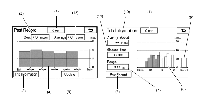
Item Outline (1) Clear Switch Clears all past information. (2) Best Fuel Consumption Displays the best (most economical) per trip fuel consumption. (3) Trip Information Switch Changes to the average per minute fuel consumption screen. (4) Average Per Trip Fuel Consumption
-
Displays the current record and the last 5 average per trip fuel consumption records or the current record and those since clear was last selected.
-
Starts calculating the average fuel consumption when the average fuel consumption displayed on the combination meter assembly is reset.
(5) Update Switch
-
Restarts calculation of the average fuel consumption value.
-
Sends the average fuel consumption reset signal to the combination meter assembly to update the graph.
(6) Past Record Switch Changes to the Past Record (per trip) fuel consumption screen. (7) Cruising Range Displays the approximate drivable distance. (8) Average Per Minute Fuel Consumption
-
Displays the value that has been calculated by the combination meter assembly, which is based on the driven distance and the volume of fuel consumed (fuel injection signal), provided that the engine switch is on (IG).
-
Displays the average fuel consumption for the last minute, or since clear was last selected.
(9) Current Per Minute Fuel Consumption Displays the instantaneous (Current) fuel consumption value that has been calculated by the combination meter assembly, which is based on the driven distance and the volume of fuel consumed (fuel injection signal), provided that the ignition switch is on (IG). (10) Average Speed Displays the value that has been calculated by the combination meter assembly, which is based on the distance driven and time elapsed since the engine switch is turned to on (IG). (11) Elapsed Time Displays the value that has been calculated by the combination meter assembly, which is based on the time elapsed since the engine switch is turned to on (IG). (12) Average Fuel Consumption Displays the average fuel consumption for this trip and the previous 5 trips. -
-
-
Setup Screen
-
The settings for the functions of the multi-display are available from the setup screen.
Item Outline General Settings
-
Time zones and the on/off setting of daylight saving time and automatic adjustment of the clock can be changed. *1, *2, *3
-
The language can be selected. *1, *3, *4
-
The voice recognition language can be selected.*1
-
The unit of measurement for fuel consumption can be changed. *1, *2, *3, *4The unit of measurement for fuel consumption can be changed. *1, *2, *3, *4
-
The startup/screen off images can be customized:
-
Images can be copied from a USB device
-
Images can be deleted
-
An image can be set as the startup or screen off image
-
Automatic return from the audio or air conditioning screen to the home screen after audio or air conditioning operation can be changed.
-
The color of the screen buttons can be changed.*1, *2, *3
-
Beep sound can be set.
-
Registered information (personal data) can be cleared.
-
Navigation system program can be updated.
-
Third party software information used in the navigation system, such as notices, can be enlisted.
-
Gracenote database can be updated.*1
Voice Settings
-
The voice guidance volume can be adjusted or switched off.
-
Voice recognition prompts can be set.*1, *2
-
Voice guidance while using the audio and visual system or air conditioning can be set.
-
Voice guidance during route guidance can be set.*1, *2, *3
-
Desired guidance tone can be set.*3
Bluetooth Settings
-
Bluetooth device registration settings can be changed:
-
Register a Bluetooth device
-
Delete the Bluetooth device
-
Select the Bluetooth device
-
Edit the Bluetooth device
-
Bluetooth system settings can be changed:
-
Automatic connection to a Bluetooth device
-
Bluetooth device name
-
Bluetooth device PIN-code
-
Display of Bluetooth device connection status
-
Bluetooth device profile
-
Bluetooth internet connection can be set up.*1
Wi-Fi Settings*1*4
-
The Wi-Fi function can be switched on/off.
-
Available networks that can be connected can be displayed.
-
Available networks that can be connected can be searched for.
-
A Wi-Fi Protected Setup compatible Wi-Fi device can be connected quickly.
-
Wi-Fi settings can be changed:
-
The networks list can be edited
-
An automatic connection message can be set
Audio Settings
-
Sound quality can be adjusted.*1
-
Radio setting can be changed: *1, *2, *3
-
The listing order of the station list can be set
-
Automatically seek an FM station that regularly broadcasts traffic information and the station broadcasts
-
An FM station providing good reception is automatically selected if current reception worsens
-
Switching over to a broadcasting station within the same local program network
-
The FM radio text feature can be set
-
DAB setting can be changed:*1, *2
-
L-band in the tune range can be set
-
Automatically seek a DAB station that regularly broadcasts traffic information and the station broadcasts
-
A DAB station providing good reception is automatically selected if current reception worsens
-
The DAB text feature can be set
-
An input terminal for iPod video sound signals can be selected.
-
An input video signal format can be selected.
-
Cover art settings can be changed:*1, *2
-
Cover art display in DISC mode*1
-
Cover art display in USB mode
-
Priority setting of the Gracenote database cover art in USB mode
-
Cover art display in iPod mode
-
Priority setting of the Gracenote database cover art in iPod mode
-
Data recorded to the sound library can be edited:*4
-
Edit an album
-
Delete an album
-
Confirm the hard drive information
-
DVD settings can be changed:
-
Audio language
-
Subtitle language
-
DVD video menu language
-
Multi-angle mark display during multi-angle compatible disc playback
-
Viewer restriction level
-
Auto start playback
-
Volume difference adjustment between the lowest and highest volume
Navigation Settings*3 The Navigation Settings can be used to:
-
Set detailed navigation settings such as average cruising speed.
-
Set detailed navigation settings such as displayed POI icon categories.
-
Set detailed navigation settings such as display of 3D landmarks.
-
Displaying the speed limit of the road currently being used can be set.
-
The function that magnifies the map scale as the vehicle guidance point can be set.
-
Set the display of pop-up information.
-
Manual adjustment of the current vehicle position mark.
-
Display the coverage areas and legal information.
Navigation Settings*1 The Navigation Settings can be used to:
-
Set detailed online search settings such as:
-
Synchronized settings of the online search portal site and navigation system
-
Automatic accumulated data downloading settings from the portal site
-
Roaming warning message settings
-
Memorization settings of the user name and password used when connecting to the portal site
-
Search engine settings of the online search
-
Deletion of the online search history
-
Change of the user name and password used when connecting to the portal site
-
Deletion of the user name and password used when connecting to the portal site
-
Set detailed navigation settings such as average cruising speed.
-
Set detailed navigation settings such as displayed POI icon categories.
-
Set detailed navigation settings such as display of 3D landmarks.
-
Set the speed limit of the road currently being used.
-
Set the function that magnifies the map scale as the vehicle approaches a guidance point.
-
Set the cautionary message display shown when a regulated street is included in the route.
-
Set the display of pop-up information.
-
Manually adjust the current vehicle position mark.
-
Display the coverage areas and legal information.
Navigation Settings*2 The Navigation Settings can be used to:
-
Set and edit the home.
-
Set special memory points.
-
Set memory points.
-
Set and edit areas to avoid.
-
Delete previous destinations.
-
Set detailed navigation settings such as:
-
The visual city map display
-
Display of 3D landmarks
-
The daytime map color
-
The nighttime map color
-
The character size on the map
-
The display of the scale switching messages
-
The merging lane guidance
-
The warning point guidance
-
The cross-border guidance
-
The usage of the G-information mark synchronized service
-
The display of the 3D intersection zoomed map
-
The automatic zooming function
-
The average cruising speed
-
Animation of some screen displays
-
The displayed POI icon categories
-
The display of the 3D city map
-
The viewing angle of the 3D map
-
User's customize settings
-
Manual adjustment of the current vehicle position mark
Navigation Settings*4 The Navigation Settings can be used to:
-
Set and edit the home.
-
Set preset destinations.
-
Set memory points.
-
Delete previous destinations.
-
Set detailed navigation settings such as:
-
The visual city map display
-
Display of 3D landmarks
-
The daytime map color
-
The nighttime map color
-
The character size on the map
-
The display of the scale switching messages
-
The merging lane guidance
-
The warning point guidance
-
The cross-border guidance
-
The display of the 3D intersection zoomed map
-
The automatic zooming function
-
The average cruising speed
-
The displayed POI icon categories
-
The display of the 3D city map
-
The viewing angle of the 3D map
-
Manual adjustment of the current vehicle position mark
-
Transfer memory points stored in a USB memory device or disc to the system.
-
Copy memory points to a USB memory device or disc for backup.
Telephone Settings
-
A Bluetooth phone can be registered or connected.
-
Phone sound settings can be changed:
-
Ring tone
-
Ring tone volume
-
Message readout volume*1, *2
-
SMS/MMS incoming tone*1, *2
-
SMS/MMS incoming tone volume*1, *2
-
E-mail incoming tone*1, *2
-
E-mail incoming tone volume*1, *2
-
In-call volume
-
Contact settings can be changed:*1, *3
-
Contacts can be transferred from the connected cellular phone to the system, or added, edited, and deleted*5
-
Favorites list registration
-
Contacts deletion from the call history*3
-
Contact/Call history settings can be changed:*2, *4
-
Automatic contact/history transfer function settings when a PBAP compatible Bluetooth phone is connected
-
Contacts update
-
Favorites list registration
-
Contacts deletion from the favorites list
-
Contact image display
-
Call history deletion*6
-
New contact addition to the contact list*6
-
Contact list editing*6
-
Contact deletion from the contact list*6
-
Message function settings can be changed:*1, *2
-
Message forwarding from cellular phones
-
Automatic message readout
-
SMS/MMS notification popup
-
E-mail notification popup
-
Vehicle signature on outgoing messages
-
Message read status on phone update
-
Incoming SMS/ MMS display when an SMS/MMS message is received
"Full Screen": The incoming SMS/MMS display screen is displayed and can be operated on the screen. "Drop-Down": A message is displayed on the upper side of the screen and can be operated only via the steering wheel switches.
-
Incoming e-mail display when an e-mail is received
"Full Screen": The incoming e-mail display screen is displayed and can be operated on the screen. "Drop-Down": A message is displayed on the upper side of the screen and can be operated only via the steering wheel switches.
-
Display of messaging account names on the inbox tab
-
Telephone display settings can be changed: *1, *2
-
Incoming call display
-
Display of the automatic contact/history transfer completion message
-
Automatic contact/history transfer (only available with Bluetooth phones that support PBAP) *1
-
Contact list sorting*1
-
Contact image display*1
-
Phone display settings can be changed:*3
-
Incoming call display
-
Display of the automatic contact/history transfer completion message
-
Display of the automatic phonebook/history transfer completion message
-
Automatic phonebook/history transfer (only available with Bluetooth phones that support PBAP)*3
-
Contact list sorting*3
-
Contact image display*3
Traffic and Parking Settings*1
-
The voice guidance for traffic information can be switched off.
-
Display of the traffic information icon can be set.
-
The detour route function can be selected.
-
When searching for a route, a detoured route search that avoids traffic jams and so forth can be set.
-
The selection of traffic stations can be set to auto/manual.
-
The selected station can be displayed.
-
TPEG traffic information receive settings can be used to:
-
Automatically update more frequently
-
Automatically update less frequently
-
Update manually
-
Cancel TPEG traffic information reception via Wi-Fi or a Bluetooth device
-
The roaming function of TPEG traffic information can be set.
-
Traffic information can be set to be received automatically, or to receive RDS-TMC traffic information only.
-
Display of parking icons can be displayed on the map can be set.
-
Parking lot information reception can be set.
-
The roaming function of parking lot information can be set.
Traffic Information Settings*7
-
The FM station currently providing traffic information can be displayed.*2
-
The voice guidance for traffic information can be switched off.*3
-
Display of the traffic information icon can be set.
-
The detour route function can be selected.*2
-
The usage of traffic information for estimating arrival time can be set.*2
-
The display of an arrow for free flowing traffic can be set.*2
-
The traffic incident voice warning can be set.*2
-
The avoid traffic function can be set to auto/manual.*3
-
The selection of traffic stations can be set to auto/manual.*3
-
The selected station can be displayed.*3
RTIC/Traffic Information Settings*4
-
The display of traffic information can be set.
-
Voice guidance for RTIC/traffic information can be set.
-
Traffic congestion consideration search can be set.
-
When using a Bluetooth device for data communication, a G-route search point can be set.
-
Driving record uploading can be set.
-
FM station selection for RTIC can be set.
G-BOOK settings*4 The G-BOOK settings can be used to:
-
Set detailed functions:
-
Canceling the Contract
-
Setting the system to read the contents of the browser aloud automatically
-
Editing the My Request
-
Editing fixed form sentence of the software keyboard
-
Set privacy setting:
-
Communication lock
-
Changing the PIN number
-
Displaying the PIN number
Vehicle Settings
-
Settings can be changed for the following maintenance items:
-
ENGINE OIL
-
OIL FILTER
-
ROTATION
-
TYRE/Tires
-
BATTERY
-
BRAKE PAD
-
WIPERS
-
LLC/Coolant
-
BRAKE OIL
-
ATF/Trans. fluid
-
SERVICE
-
AIR FILTER
-
PERSONAL
-
Reminder
-
Delete all
-
Reset all
-
Set dealer
-
Customizable vehicle settings can be changed.
-
Toyota Parking Assist-sensor system adjustment.*8
-
Blind spot monitor system adjustment.*9
*1: Models for Europe
*2: Models for Australia
*3: Models for G.C.C. Countries
*4: Models for China
*5: For PBAP compatible models
*6: PBAP non-compatible phone, or PBAP compatible phone with the automatic telephone number transfer function set to off
*7: Except models for Europe and China
*8: Models with Toyota parking assist-sensor system
*9: Models with blind spot monitor system
Tech Tips
Gracenote.:

Gracenote, CDDB, MusicID, Playlist Plus, MediaVOCS, the Gracenote logo and logotype, and the "powerd by Gracenote" logo are either registered trademarks or trademarks of Gracenote, Inc. in the United States and/or other countries. -
-
-
PRECAUTION
-
When ejecting the microSD card, observe the following precautions to avoid damaging it.
-
The microSD card (disc player disc) stores map data or various programs which are required to operate the navigation system. With the microSD card (disc player disc) removed, the navigation system will not operate properly. Do not remove the microSD card (disc player disc) unless necessary, such as for a map update.

-
Do not insert anything other than a microSD card (disc player disc) into the microSD card slot after removing the microSD card (disc player disc).
-
Do not insert a dusty or dirty microSD card (disc player disc) into the microSD card slot, as it may cause a malfunction.
-
After the microSD card (disc player disc) is inserted, make sure that it is secure in the microSD card slot.
-
-
When handling a microSD card (disc player disc), observe the following precautions. Failure to do so may cause a malfunction.
-
Do not touch the metal contacts of the microSD card (disc player disc) with your fingers or metal objects.
-
Do not bend, drop or strike a microSD card (disc player disc), as it is a precision electronic component and may become damaged.
-
Avoid the following environments when storing a removed microSD card (disc player disc). Failure to do so may cause the microSD card (disc player disc) to malfunction and generate errors in the navigation system.
-
Areas where static electricity or electrical noise is present
-
Extremely hot or humid areas
-
Areas exposed to direct-sunlight
-
Areas where condensation may form
-
Areas where corrosive gases may be generated
-
-
-
Do not peel the label on the microSD card or attach a new label or sticker.
-
-
DIAGNOSIS
-
For details on the procedure required to enter the Service Menu screen, refer to the Repair Manual.
-