NAVIGATION SYSTEM / MULTI INFORMATION SYSTEM
-
FUNCTION OF MAIN COMPONENTS
Component Function Multi-display Assembly Displays each type of signal received from the multi-media module receiver assembly. Multi-media Module Receiver Assembly Receives and handles each type of signal and sends the signals to the multi-display assembly. Navigation Antenna Assembly Receives signals from the GPS satellites and transmits them to the multi-media module receiver assembly. Combination Meter Assembly Transmits vehicle speed signals to the multi-media module receiver assembly. Steering Pad Switch Assembly Enables the driver to operate the navigation system from the steering pad switches. Telephone Microphone Assembly Transmits voice signals to the multi-media module receiver assembly. Television Display Assemblies*1
-
Display the navigation screen (information).
-
Receive signals from the remote controller.
Telematics Transceiver (DCM)*2 Receives signals from the navigation system which calculates the position of the vehicle, and transmits them to the call center. Telephone Antenna Assembly*2 This antenna is for a cellular phone. It is compatible with the transmission and reception of frequency bands of cellular phones. The assembly transmits signals from the telematics transceiver (DCM) and receives signals from the call center.
-
*1: Models with Rear Seat Entertainment system (RSE)
-
*2: Models with telematics transceiver (DCM)
-
-
FUNCTION
-
Navigation Screen
-
The navigation computer calculates the present position and direction of travel, then determines a route and calculates the driving distance based on the following information sources:
-
Map data in the micro SD card
-
Global Positioning System (GPS) satellites
-
Built-in gyro sensor
-
Vehicle speed signal
-
Reverse signal
-
Parking brake signal
-
Radio Data System Traffic Message Channel (RDS-TMC) and Transport Protocol Experts Group (TPEG) signal*1
-
Radio Data System Traffic Message Channel (RDS-TMC) signal*2
-
Real-time Traffic Information of China (RTIC) signal*3
-
Telematics Data (G-BOOK) signal*3
-
*1: Models for Europe
-
*2: Except models for Europe and China
-
*3: Models for China
Item Function Map Display Taillight-interlocked Map Color Change Changes the color of the map screen that is displayed when the taillight are turned on. North Up/Heading Up
-
If North up is selected, regardless of the direction of vehicle travel, north is always up.
-
If Heading up is selected, the direction of vehicle travel is always up.
3D Display Displays a 3-dimensional (3D) view of the map. 3D City Model Map*1
-
Displays some areas of major cities on the 3-dimensional (3D) city model map when the map scale is set to 100 m or less.
-
Always displayed in Heading up mode.
Multi-step Scale Display Changes the map scale in 14 steps.*1 Changes the map scale in 13 steps.*2 Direct Scale Change Directly selects and displays map scale. Street Name Indication on Scrolled Map Displays the street name and city name even when the map screen is being scrolled. Road Number Sign Board Diplays the road number on the map. Point of Interest Display Displays selected types of interest as marks on the map. Multiple Display Function Displays different modes on a screen that is split into 3 views or 2 views. Compass Mode Screen*1 Displays the direction of travel and detailed data of the present location. Route Guidance Demonstration Demonstrates the route guidance to the destination. Route Trace Registration*1
-
A traveled route (up to 200 km (124 miles)) can be stored with a name by setting a start point and end point.
-
The stored traveled route can be displayed on the map screen.
-
Available when the map scale is set to 50 km (30 miles) or less.
RDS-TMC and TPEG Service Information Display*3 Displays the traffic icons, arrows and indicators when RDS-TMC or TPEG service information is being received. RDS-TMC Display*4 Displays RDS-TMC icons, arrows, popup messages and indicators when RDS-TMC service is being received. RTIC Traffic Information Display*2 Displays RTIC icons, arrows and indicators when RTIC service is being received. Destination Search Preset Destination Memory Search Sets a pre-registered point as a destination point while driving. Address Search*1 Information can be entered in the order of: area, town name, street name and house number. Address/Intersection Search*2 Information can be entered in the order of: province, city name, street name, house number and intersection. Point of Interest Search Searches for a point of interest by selecting the area from the category. Online Search Allows use of an internet search engine to set a destination using the most up to date information.*1 Latest information found using the Mapbar can be set as a destination.*1 Previous Destination Search Stores the coordinates, names, and date of up to 100 locations that have been set as destinations in the past. QR Code Search*3 POI information is displayed as a QR code. By scanning this code by cellular phone, destination information can be obtained. Map Search A destination can be set by using the cursor on map. Memory Point Search Sets a destination from the registered memory point. Intersection Search*1 By specifying 2 streets, the point at which they intersect is set as the destination point. Motorway Entrance or Exit Search*1 Searches for the destination by the name of the street that connects to a motorway (highway) entrance or exit. Coordinate Search*1 A destination can be input by entering its coordinates. Phone Number Search A destination can be input by entering its phone number. Postal Code Search*1 A destination can be input by entering its postal code. Point of Interest Near Cursor Search A destination can be set by selecting the search point and point of interest category. MAP CODE Search*2 A destination can be set using a MAP CODE. Panoramio Search*3 A destination can be set using location information applied to phones searched for in Panoramio. G Search*2 A destination can be set using information from the web site (G-memory point). POI Smartphone Search*2 The POI searched for using a smartphone can be obtained and set as a destination. Voice Recognition Search*5 A destination can be set up by voice command input. Route Search Multiple Destination Setting Sets multiple destinations. It can also rearrange the sequence of the destinations. Multiple Route Search Searches for multiple routes. Search Condition Designation Searches for the recommended route, the shortest route, a route that prioritizes the use of highways, a route that prioritizes the use of general roads and the other route. Reordering Destinations Changes the order of destinations when more than one destination is selected. Detour Search Changes the route to detour around a section of the route. Regulated Road Consideration Performs searches which consider regulated roads. Avoidance Area Searches for a route that avoids a designated area. Auto Avoid Traffic Search Automatically changes to another route to avoid heavy congestion. Guidance Voice Guidance Provides voice guidance about the distance and the direction of travel to a destination point based on road conditions and vehicle speed. Next Turn Guidance Provides guidance about the distance to the next turn and indicates the direction of the turn using an arrow. Motorway (Freeway, Highway) Mode Display Displays the distance to the next junction and exit, or POIs in the vicinity of the motorway exit. Motorway (Freeway, Highway) Exit or Junction Display When the vehicle approaches an exit or junction, the motorway guidance screen will be displayed. Motorway (Freeway, Highway) Direction of Travel Display Displays the direction of travel to take on the motorway. Real Freeway (Highway) Junction Display*2 Displays the junction and signage in 3D in the vicinity of a major junction while driving. Intersection Zoom-in Display Zooms in the map display when approaching an intersection. Turn List Display*1 Displays a turn list on the right side of the 2-screen display. Arrow (Turn-by-Turn) Display*1 Displays the direction of the next turn and the distance to the turn on the right side of the 2-screen display. Lane List Display*2 Display a lane list on the right side of the 2-screen display. Distance-to-destination Display Displays the distance from the present location to the destination. Importing Stored Route Guidance*3 Starts the guidance for the route set using the route information that is stored at the Lexus center and imported. Driver Support Information icon Display Displays warning icons when the vehicle approaches the area, such as a school zone, railway crossing or high accident zone. Route Information Bar Display Displays the following information:
-
Street name of the current location.
-
Distance and travel time to the destination.
-
Distance to the destination and estimated time of arrival.
-
Distance to the destination and an arrow facing the destination (Case of being off the route during the guidance).
Traffic Bar Display*3 Displays traffic information of congestions or accidents on the route using the traffic bar. Others Voice Recognition*3 Recognizes pre-programmed system commands spoken to operate the navigation system. Map Coverage Information Display Displays the map area that is stored on the micro SD card.
-
*1: Except models for China
-
*2: Models for China
-
*3: Models for Europe
-
*4: Except models for Europe and China
-
-
-
Information Screen
-
The functions of the information screen display are listed below:
Item Function Fuel Consumption Information about fuel consumption per minute or per trip can be displayed. Traffic Information*1 By receiving the RDS-TMC and TPEG service, a list of the current traffic incidents is displayed along with information on the incident's distance and position relative to the vehicle. Traffic Incidents*1 By receiving the RDS-TMC service, a list of the current traffic incidents is displayed along with information on the incident's distance and position relative to the vehicle. Parking information*1 By receiving the TPEG service, the location and vacancy status of the parking lots can be displayed. The parking lot can also be set as a destination. Street View*1 By connecting to the Internet, Google Street View can be displayed. Panoramio*1 By connecting to the Internet, users' pictures, comments and other information uploaded to Panoramio can be displayed. Operator Service*2 Display of Information Acquired from the Operator Service A telephone call can be made to the operator service. G-BOOK.com*2 G-BOOK on line services can be operated. MY Request*2 Contents can be registered and registered contents can be accessed. Information Check*2 Display of Information Acquired from the Operator Service Acquired information can be displayed and manually updated.
-
*1: Models for Europe
-
*2: Models for China
-
-
The fuel consumption screen is displayed as illustrated below. This screen has the display functions listed below.
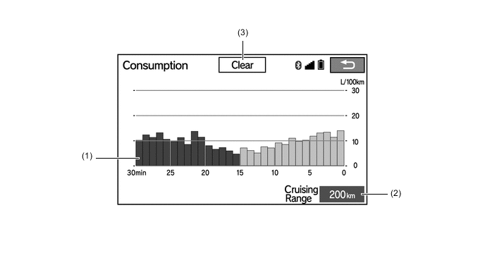
Item Outline (1) Average Per Minute Fuel Consumption Displays the value that has been calculated by the combination meter assembly, which is based on the driven distance and the volume of fuel consumed (fuel injection signal), since that the engine switch was turned on (IG). (2) Cruising Range Displays the approximate drivable distance. (3) Clear Switch Clears all past information.
-
-
Setup Screen
-
The settings for the functions of the multi-display are available from the setup screen.
Item Function General Settings
-
Time zones and the on/off setting of daylight saving time and automatic adjustment of the clock can be changed.*1, *2, *3
-
The language can be selected.*1, *2, *3
-
The voice recognition language can be selected.*1
-
The unit of measurement for fuel consumption can be changed.
-
The startup/screen off images can be customized:
-
Images can be copied from a USB device
-
Images can be deleted
-
An image can be set as the startup or screen off image
-
Automatic return from the audio or air conditioning screen to the home screen after audio or air conditioning operation can be changed.
-
The color of the screen buttons can be changed.*1, *2, *3
-
Beep sound can be set.
-
Registered information (personal data) can be cleared.
-
Navigation system program can be updated.
-
Third party software information used in the navigation system, such as notices, can be enlisted.
-
Gracenote database can be updated.*1
Voice Settings
-
The voice guidance volume can be adjusted or switched off.
-
Voice recognition prompts can be set.*1, *2, *3
-
Voice guidance while using the audio and visual system or air conditioning can be set.
-
Voice guidance during route guidance can be set.
-
Desired guidance tone can be set.*1, *2, *3
Bluetooth Settings
-
Bluetooth device registration settings can be changed:
-
Register a Bluetooth device
-
Delete the Bluetooth device
-
Select the Bluetooth device
-
Edit the Bluetooth device
-
Bluetooth system settings can be changed:
-
Automatic connection to a Bluetooth device
-
Bluetooth device name
-
Bluetooth device PIN-code
-
Display of Bluetooth device connection status
-
Bluetooth device profile
-
Bluetooth internet connection can be set up.*1
Wi-Fi Settings*1
-
The Wi-Fi function can be switched on/off.
-
Available networks that can be connected can be displayed.
-
Available networks that can be connected can be searched for.
-
A Wi-Fi Protected Setup compatible Wi-Fi device can be connected quickly.
-
Wi-Fi settings can be changed:
-
The networks list can be edited
-
An automatic connection message can be set
Audio Settings
-
Sound quality can be adjusted.*1
-
Radio setting can be changed:*1, *2, *3
-
The listing order of the station list can be set
-
Automatically seek an FM station that regularly broadcasts traffic information and the station broadcasts
-
An FM station providing good reception is automatically selected if current reception worsens
-
Switching over to a broadcasting station within the same local program network
-
The FM radio text feature can be set
-
DAB setting can be changed:*1
-
L-band in the tune range can be set
-
Automatically seek a DAB station that regularly broadcasts traffic information and the station broadcasts
-
A DAB station providing good reception is automatically selected if current reception worsens
-
The DAB text feature can be set
-
An input terminal for iPod video sound signals can be selected.
-
An input video signal format can be selected.
-
Cover art settings can be changed:*1
-
Cover art display in DISC mode
-
Cover art display in USB mode
-
Priority setting of the Gracenote database cover art in USB mode
-
Cover art display in iPod mode
-
Priority setting of the Gracenote database cover art in iPod mode
-
Data recorded to the sound library can be edited:*4
-
Edit an album
-
Delete an album
-
Confirm the hard drive information
-
DVD settings can be changed:
-
Audio language
-
Subtitle language
-
DVD video menu language
-
Multi-angle mark display during multi-angle compatible disc playback
-
Viewer restriction level
-
Auto start playback
-
Volume difference adjustment between the lowest and highest volume
Navigation Settings*1 The Navigation Settings can be used to:
-
Set detailed online search settings such as:
-
Synchronized settings of the online search portal site and navigation system
-
Automatic accumulated data downloading settings from the portal site
-
Roaming warning message settings
-
Memorization settings of the user name and password used when connecting to the portal site
-
Search engine settings of the online search
-
Deletion of the online search history
-
Change of the user name and password used when connecting to the portal site
-
Deletion of the user name and password used when connecting to the portal site
-
Set detailed navigation settings such as average cruising speed.
-
Set detailed navigation settings such as displayed POI icon categories.
-
Set detailed navigation settings such as display of 3D landmarks.
-
Set the speed limit of the road currently being used.
-
Set the function that magnifies the map scale as the vehicle approaches a guidance point.
-
Set the cautionary message display shown when a regulated street is included in the route.
-
Set the display of pop-up information.
-
Manually adjust the current vehicle position mark.
-
Display the coverage areas and legal information.
Navigation Settings*4 The Navigation Settings can be used to:
-
Set and edit the home.
-
Set special memory points.
-
Set memory points.
-
Set and edit areas to avoid.
-
Delete previous destinations.
-
Set detailed navigation settings such as:
-
The visual city map display
-
Display of 3D landmarks
-
The daytime map color
-
The nighttime map color
-
The character size on the map
-
The display of the scale switching messages
-
The merging lane guidance
-
The warning point guidance
-
The cross-border guidance
-
The usage of the G-information mark synchronized service
-
The display of the 3D intersection zoomed map
-
The automatic zooming function
-
The average cruising speed
-
Animation of some screen displays
-
The displayed POI icon categories
-
The display of the 3D city map
-
The viewing angle of the 3D map
-
User's customize settings
-
Manual adjustment of the current vehicle position mark
Navigation Settings*2, *3 The Navigation Settings can be used to:
-
Set detailed navigation settings such as average cruising speed.
-
Set detailed navigation settings such as displayed POI icon categories.
-
Set detailed navigation settings such as display of 3D landmarks.
-
Displaying the speed limit of the road currently being used can be set.
-
The function that magnifies the map scale as the vehicle guidance point can be set.
-
Set the display of pop-up information.
-
Manual adjustment of the current vehicle position mark.
-
Display the coverage areas and legal information.
Telephone Settings
-
A Bluetooth phone can be registered or connected.
-
Phone sound settings can be changed:
-
Ring tone
-
Ring tone volume
-
Message readout volume*1
-
SMS/MMS incoming tone*1
-
SMS/MMS incoming tone volume*1
-
E-mail incoming tone*1
-
E-mail incoming tone volume*1
-
In-call volume
-
Contact settings can be changed:*1, *2, *3
-
Contacts can be transferred from the connected telephone to the system, or added, edited, and deleted*5
-
Favorites list registration
-
Contacts deletion from the call history
-
Contact/Call history settings can be changed:*4
-
Automatic contact/history transfer function settings when a PBAP compatible Bluetooth phone is connected
-
Contacts update
-
Favorites list registration
-
Contacts deletion from the favorites list
-
Contact image display
-
Call history deletion*5
-
New contact addition to the contact list*5
-
Contact list editing*5
-
Contact deletion from the contact list*5
-
Message function settings can be changed:*1
-
Message forwarding from cellular phones
-
Automatic message readout
-
SMS/MMS notification popup
-
E-mail notification popup
-
Vehicle signature on outgoing messages
-
Message read status on phone update
-
Incoming SMS/ MMS display when an SMS/MMS message is received
-
"Full Screen": The incoming SMS/MMS display screen is displayed and can be operated on the screen.
-
"Drop-Down": A message is displayed on the upper side of the screen and can be operated only via the steering wheel switches.
-
Incoming e-mail display when an e-mail is received
-
"Full Screen": The incoming e-mail display screen is displayed and can be operated on the screen.
-
"Drop-Down": A message is displayed on the upper side of the screen and can be operated only via the steering wheel switches.
-
Display of messaging account names on the inbox tab
-
Telephone display settings can be changed:*1
-
Incoming call display
-
Display of the automatic contact/history transfer completion message
-
Automatic contact/history transfer (only available with Bluetooth phones that support PBAP)
-
Contact list sorting
-
Contact image display
-
Lexus Euro assistance 24 settings
Telephone Settings
-
Phone display settings can be changed:*2, *3, *4
-
Incoming call display
-
Display of the automatic contact/history transfer completion message*2, *6
-
Display of the automatic phonebook/history transfer completion message*2, *3, *6
-
Automatic phonebook/history transfer (only available with Bluetooth phones that support PBAP)*2, *3
-
Contact list sorting*2, *3
-
Contact image display*2, *3
Traffic and Parking Settings*1
-
The voice guidance for traffic information can be switched off.
-
Traffic information icon display can be set.
-
Detour route function can be selected.
-
When searching for a route, a detoured route search that avoids traffic jams and so forth can be set.
-
The selection of traffic stations can be set to auto/manual.
-
The selected station can be displayed.
-
TPEG traffic information receive settings can be used to:
-
Automatically update more frequently
-
Automatically update less frequently
-
Update manually
-
Cancel TPEG traffic information reception via Wi-Fi or a Bluetooth device
-
The roaming function of TPEG traffic information can be set.
-
Traffic information can be set to be received automatically, or to receive RDS-TMC traffic information only.
-
Parking icons can be displayed on the map.
-
Parking lot information reception can be set.
-
The roaming function of parking lot information can be set.
Traffic Information Settings
-
The voice guidance for traffic information can be switched off.*2, *3
-
Traffic information icon display can be set.
-
The usage of traffic information for estimating arrival time can be set.
-
The display of an arrow of free flowing traffic can be set.
-
The traffic incident voice warning can be set.
-
The avoid traffic function can be set to auto/manual.*2, *3
-
The selection of traffic stations can be set to auto/manual.*2, *3
-
The selected station can be displayed.*2, *3
RTIC/Traffic Information Settings*4
-
The display for traffic information can be set.
-
Voice guidance for RTIC/traffic information can be set.
-
Traffic congestion consideration search can be set.
-
When using a Bluetooth device for data communication, G-route search can be set.
-
Driving record uploading can be set.
-
FM station selection for RTIC can be set.
Vehicle Settings
-
Settings can be changed for the following maintenance items:
-
ENGINE OIL
-
OIL FILTER
-
ROTATION
-
TYRE/Tires
-
BATTERY
-
BRAKE PAD
-
WIPERS
-
LLC/Coolant
-
BRAKE OIL
-
ATF/Trans. fluid
-
SERVICE
-
AIR FILTER
-
PERSONAL
-
Reminder
-
Delete all
-
Reset all
-
Set dealer
-
Customizable vehicle settings can be changed.
-
LEXUS parking assist-sensor system adjustment.*7
G-BOOK Settings*4 The G-BOOK settings can be used to:
-
Select content from "My Request".
-
Set detailed functions:
-
Setting the system to read the contents of the browser aloud automatically*8
-
Canceling the Contract
-
Editing fixed form sentence of the software keyboard
-
Set privacy setting:
-
Changing the PIN number
-
Communication lock
-
Deleting a bookmark
-
Deleting the browsing history
-
Set communication settings:*9
-
Communication settings for the cellular phone
-
Username and password
-
Confirm settings before communication connection
-
Automatic communication settings
Tech Tips
-
*1: Models for Europe
-
*2: Models for G.C.C. Countries
-
*3: Destination package for South and Central America
-
*4: Models for China
-
*5: PBAP non-compatible phone, or PBAP compatible phone with the automatic telephone number transfer function set to off
-
*6: For PBAP compatible models
-
*7: Models with LEXUS parking assist-sensor system
-
*8: Models with telematics transceiver connection type G-BOOK system
-
*9: Models with cellular phone connection type G-BOOK system
-
-
-
-
DIAGNOSIS
-
For details on the procedure required to enter the Service Menu screen, refer to the Repair Manual.
-